GR 92: Stages, accommodation, and guide - Costa Brava hiking
- Aug 29, 2025
- 26 min read
Updated: Sep 3, 2025
The GR 92 is part of the GR trail network in Spain. There are two variants: a shorter route with 11 stages and an extended variant with 31 stages, which I will describe in detail in this article.
This will give you all the information you need for your trip – and you can plan your hike easily and specifically.

Content
1. Journey
2. Route
3. Accommodation
4. Weather and best time to travel
5. Further information
6. Recommended stages
7. Packing list
8. GPX and map information
9. Conclusion
GR 92
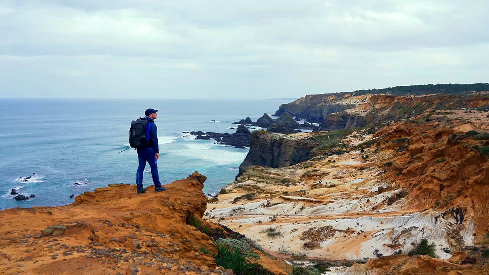
The GR 92 covers around 570 kilometers and 10,000 meters of elevation gain. The GR 92, also known as the Camino de la Costa or Sendero del Mediterráneo, is a long-distance hiking trail that runs along the entire Iberian coast. The GR 92 runs along the Spanish Mediterranean coast, from Portbou on the border with France to Tarifa, the southernmost point of Spain. It crosses the autonomous communities of Catalonia, Valencia, Murcia, and Andalusia.

GR 92 Arrival
Getting to the GR 92 is very straightforward. I recommend travelling from Barcelona, or alternatively there is also Girona Airport. From Barcelona, the cheapest way to get to the starting point in Portbou is by bus or train, or you can also take a Bold/Uber taxi. Below you will find all the important information you need for your journey:
Airplane: The nearest airport is Barcelona Airport (BCN). To find cheap flights, I highly recommend Skyscanner – a first-class app that gives you a quick overview of the best flight deals.
Bus: There are regular bus connections from the bus station in Barcelona ‘Estació d'Autobusos Nord’ to Portbou. The journey takes approximately 3.2 hours. Always book your bus tickets in advance, as reservations are required. I highly recommend the OMIO app for bookings. To get there, take the underground from the airport to Barcelona or, alternatively, a taxi.
Train: There are regular train connections from Barcelona's Passeig De Gràcia station to Portbou. The journey takes approximately 2.5 hours. I highly recommend using the OMIO app to book your tickets. To get to the station, take the underground from the airport to Barcelona or alternatively take a taxi.
Return journey: For a one-way return journey by bus, we recommend the towns of Begur, Palamos, Sant Feliu de Guíxols, Tossa de Mar and Lloret de Mar to Barcelona.
Taxi: Uber and Bold work wonderfully in Barcelona. In the Costa Brava area, you will need to use local taxi ranks, such as the taxi rank in Tossa de Mar:https://taxistossa.com/en/

GR 92 Route
The GR 92 is divided into easily walkable stages – some natural, some developed or paved – and often leads spectacularly over rocky outcrops or along wooded slopes. Depending on the section, the route can be wild and lonely or family-friendly and relaxed – mostly with a difficulty rating of T1, rarely T2.
You can stay overnight in small hotels, guesthouses or B&Bs, often with a direct sea view.
Waymarkings: The GR 92 is marked with white and red markings on signs, trees, stones and walls: horizontal bars mean that you should follow the path, angled bars indicate a turn, and a white and red cross indicates a change of direction or a route to be avoided. I have shown you the trail markings in the photos below.


Remember to insure your trip well – because a fall or other typical hiking injury can quickly result in high rescue costs. Auras Insurance offers you worldwide hiking and trekking insurance, specially designed for active travellers.
Use the discount code CJCOM to get 10% off your insurance.

GR 92 stages
The GR 92 in Spain runs along the breathtaking Costa Brava and is divided into several stages. Each of these stages offers unique landscapes, from spectacular cliffs to secluded beaches and picturesque fishing villages. Below you will find the official stages of the GR 92:
GR 92 in 11 stages:
Stage 1: Portbou - Llançà (10km and 325m ascent)
Stage 2: Llançà - Cadaqués (19.5km and 475m ascent)
Stage 3: Cadaqués - Roses (21.5km and 550m ascent)
Stage 4: Roses - El Cortalet (19km and 100m ascent)
Stage 5: El Cortalet - L'Escala (20.5km and 120m ascent)
Stage 6: L'Escala - Torroella de Montgrí (21km and 560m ascent)
Stage 7: Torroella de Montgrí - Begur (21.5 km and 390 m ascent)
Stage 8: Begur - Palamós (22.5 km and 470 m ascent)
Stage 9: Palamós - Sant Feliu de Guíxols (14 km and 135 m ascent)
Stage 10: Sant Feliu de Guíxols - Tossa de Mar (23 km and 640 m ascent)
Stage 11: Tossa de Mar - Lloret de Mar (14 km and 330 m ascent)
GR 92 Classic:
Stage 1: Portbou - Llançà (10km and 325m ascent)
Stage 2: Llançà - Cadaqués (19.5km and 475m ascent)
Stage 3: Cadaqués - Roses (21.5km and 550m ascent)
Stage 4: Roses - El Cortalet (19km and 100m ascent)
Stage 5: El Cortalet - L'Escala (20.5km and 120m ascent)
Stage 6: L'Escala - Torroella de Montgrí (21km and 560m ascent)
Stage 7: Torroella de Montgrí - Begur (21.5 km and 390 m ascent)
Stage 8: Begur - Palamós (22.5 km and 470 m ascent)
Stage 9: Palamós - Sant Feliu de Guíxols (14 km and 135 m ascent)
Stage 10: Sant Feliu de Guíxols - Tossa de Mar (23km and 640m ascent)
Stage 11: Tossa de Mar - Lloret de Mar (14km and 330m ascent)
Stage 12: Lloret de Mar - Tordera (18km and 240m ascent)
Stage 13: Tordera - Hortsavinya (13km and 530m ascent)
Stage 14: Hortsavinya - Vallgorguina (17km and 390m ascent)
Stage 15: Vallgorguina - Collado de Can Bordoi (15km and 480m ascent)
Stage 16: Collado de Can Bordoi - Collado de Font de Cera (23km and 550m ascent)
Stage 17: Collado de Font de Cera - Montcada i Reixac (16km and 320m ascent)
Stage 18: Montcada i Reixac - Baixador de Vallvidrea (17km and 590m ascent)
Stage 19: Baixador de Vallvidrea - Vicenc dels Horts (14km and 250m ascent)
Stage 20: Vicenc dels Horts - Bruguers (16km and 630m ascent)
Stage 21: Bruguers - Garraf (16km and 420m ascent)
Stage 22: Garraf - Vilanova i la Geltru (23km and 540m ascent)
Stage 23: Vilanova i la Geltru - Calafell (13km and 30m ascent)
Stage 24: Calafell - Torredembarra (17km and 30m ascent)
Stage 25: Torredembarra - Tarragona (20km and 130m ascent)
Stage 26: Tarragona - Cambrils (27km and 110m ascent)
Stage 27: Cambrils - L'Hospitalet de I'Infant (19km and 70m ascent)
Stage 28: L'Hospitalet de I'Infant - L'Ametlla de Mar (22km and 230m ascent)
Stage 29: L'Ametlla de Mar - L'Ampolla (15km and 50m ascent)
Stage 30: L'Ampolla - Amposta (20km and 30m ascent)
Stage 31: Amposta - Ulldecona (27km and 700m ascent)

GR 92 accommodations
Along the GR 92 in Spain, you will find a wide range of accommodation options – from cosy guesthouses and hotels to campsites. You can book directly via the following links on my partner platform Booking.com – at no extra cost to you. As always, the earlier you book, the cheaper the prices. For a small surcharge, you can also cancel most accommodations free of charge in case of emergency.
Starting point: Portbou
Stage 1: Llanca
Stage 2: Cadaques
Stage 3: Roses
Stage 4: El Cortalet (Sant Pere Pescador)
Stage 5: L'Escala
Stage 6: Torroella de Montgrí
Stage 7: Begur
Stage 8: Palamós
Stage 9: Sant Feliu de Guíxols
Stage 10: Tossa de Mar
Stage 11: Lloret de Mar

GR 92 guide
My experiences on the GR 92 are as varied as the long-distance hike itself. Here you will find a rough overview of what to expect on your upcoming tour.
Getting there:
Getting to Portbou was very straightforward. I booked a flight to Barcelona – a large airport with numerous connections to many European cities. Once I arrived in Barcelona, I took a taxi straight to the train station in Passeig De Gràcia. From there, I took the train to Portbou. I spent my first night in a lovely guesthouse, which included a delicious breakfast the next morning.
Stage 1: Portbou – Llançà (10 km and 325 m elevation gain)
Portbou is a small Spanish municipality right on the border with France. The town is particularly well known for its beautiful, historic railway station. Portbou is also considered an ideal starting point for numerous hikes along the coast. The town is easily accessible by train from Barcelona.
As soon as you leave Portbou, you will be greeted by an impressive coastal panorama. Tip: Before you leave Portbou, take a look at the Església de Santa Maria (church). Your first stage is a pleasant introductory tour: about 10 km with only a few climbs. After a short climb just behind Portbou, you will be rewarded with a wonderful view of Cap de Creus – a highlight that awaits you the next day. Tip: Take a detour to the Canons de Colera and Cap de Ras (Punta del Cap Ras). Cap Marcer, which is almost directly on your route, is also particularly scenic.
A little later, you will reach the beach for the first time. If the temperatures allow it, you can enjoy a refreshing dip in the sea here.
The day ends in the coastal town of Llançà. Here you have a choice: either stay in accommodation right by the sea or opt for a night in the charming, historic town centre – about a 30-minute walk from the beach. The centre of Llançà captivates with its medieval flair, numerous bars and restaurants, and good local amenities including a supermarket and pharmacy.

Stage 2: Llançà - Cadaqués (19.5 km and 475 m elevation gain)
Start your day with a hearty breakfast and enjoy the fresh, salty Mediterranean air. Today, a longer but technically not too difficult stage awaits you, taking you to the steep cliffs and nature reserve of Cap de Creus. The route is varied – a mix of well-maintained paths and stony hiking trails.
After Llançà, you will soon reach the coastal town of El Port de la Selva – perfect for a coffee break or a longer rest. Take advantage of the opportunity, because after this town there are no further places to stop without making a detour.
Tip: In El Port de la Selva, it is worth taking a short detour around La Carbonera (121 m). From the summit, you can enjoy magnificent views of the coast and the sea. At the back, you will also find an idyllic bay. The harbour is also a great place to stop for a short break.
Then the more challenging part of the stage begins: From the coast, the trail now leads you along narrow, partly stony paths into the hinterland – into the wild nature reserve of Cap de Creus. The landscape becomes rougher and more unspoilt.
Tip: If you still have the strength and sure-footedness, you can climb the Roques de la Regalada (275 m). The ridge runs parallel to the hiking trail and rewards you with spectacular views.
At the end of the route, the view suddenly opens up – the sea appears in the distance. Ahead of you lies a beautiful descent to Cadaqués, your destination for the day.
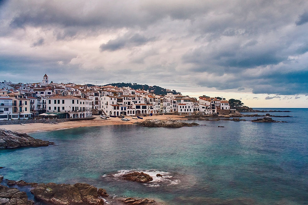
Cadaqués is considered one of the most beautiful fishing villages on the Costa Brava – and for many, the highlight of the entire GR 92. With its whitewashed houses nestled harmoniously against the rocky coastline, the village exudes a very special charm. Numerous artists, including Salvador Dalí, have found inspiration here.
There is a wide range of accommodation and restaurants to choose from. Enjoy the evening by the sea with traditional Spanish cuisine – freshly caught fish, paella or tapas invite you to indulge.
Further tips for the evening:
Visit the El Molí d'en Cay viewing platform. If you still have energy, it is worth making a detour to this viewpoint with its historic tower. The view over the bay of Cadaqués is particularly breathtaking at sunset.
The Catholic church in the town centre is also a real architectural highlight and well worth a visit.
As there is little shade along the entire GR 92 and you will be exposed to the wind all day long, I recommend my beloved ‘Piz Buin Mountain’ sun cream.
"The sun also shines behind the clouds." Quote from Karl Friedrich Wilhelm Wander
Stage 3: Cadaqués - Roses (21.5 km and 550 m elevation gain)
The next morning, a beautiful coastal hiking trail to Roses awaits you. Along the way, you will discover several picturesque bays. The first part of the stage takes you through the interior of Cap de Creus – on beautiful paths, accompanied by recurring views of the surrounding landscape.
About halfway along the route, you will finally reach the sea – in a particularly enchanting bay that invites you to take a short break.
Note for hikers with a fear of heights: Between Cala Calitjàs and Roses, the normal route runs directly along a steep slope. If you feel uncomfortable on such paths, you can also take a detour inland from Cala Calitjàs – preferably via easy forest roads to Platja de l'Almadrava. From there, you can continue your hike along the coast.
Tip: In this area, you have the opportunity to visit Cap de Norfeu. To do so, you will climb 151 metres to Puig d'en Mamet. Several sights await you there: the medieval cave Cova de les Ermites, as well as the viewpoints Torre de Norfeu, La Trona and Cavall Bernat.
After Cap de Norfeu, the second part of the stage begins – most of which runs directly along the coast. You can expect secluded bays and impressive views of the sea.
Tip: If you still have energy left – or if you skipped Cap de Norfeu – take a detour to Puig des Gall (253 m), a local mountain with great views. The easiest ascent starts at l'Almadrava.
Your stage finally ends in Roses, a larger town with good infrastructure, numerous accommodation options (hotels and B&Bs) and comprehensive amenities.
Please note: The weather in Spain, especially on the coast, can be very changeable, particularly in spring and autumn. Strong winds or sudden rain are not uncommon. Therefore, pack light but weatherproof clothing and make sure you have adequate sun protection.
I would highly recommend a breathable rain poncho

Stage 4: Roses – El Cortalet (19 km, approx. 100 m elevation gain)
The next day, a longer but very flat stage through the marshlands of the interior to El Cortalet awaits you. A very beautiful route awaits you.
Tip: As this route only takes about six hours, you will have time in the morning to visit the Museu de la Ciutadella de Roses in Roses. Please check the current opening hours in advance.
While still in Roses, you also have the opportunity to visit the citadel before your route takes you further through the Aiguamolls de l'Empordà Natural Park. This offers numerous opportunities for nature observation – birds such as flamingos and storks can often be seen here.
On your way, you will also pass through the pretty town of Castelló de Empúries, whose historic centre invites you to linger.
The stage does not end in a town, but you can spend the night at the Almata campsite or stay at one of the surrounding accommodations. Accommodations in and around Sant Pere Pescador are particularly suitable for this.
Note: From El Cortalet to Sant Pere Pescador, you will need to allow for an additional 2–3 kilometres to reach your accommodation. In the Accommodation section, I have listed all the available options for you.

Stage 5: El Cortalet - L'Escala (20.5 km and 120 m elevation gain)
This stage is again very flat and offers a beautiful route lined with historical sights. You will walk along the Fluvià River on well-maintained paths, past orchards and farmland, to Sant Pere Pescador.
Here you leave the nature park and continue to follow the course of the river to l'Armentera. This small village offers the last opportunity to stock up on supplies before heading further inland.
Shortly before L'Escala, you finally reach the charming coastal village of Sant Martí d'Empúries.
Tip: Take time to visit the medieval old town and the impressive Roman settlement.
The following highlights await you there:
Archaeology Museum Empúries
Empúries Roman City Ruins
Temple d'August
Porta i Muralla Sud
Columna Emporitana
Your stage ends in the beautiful harbour town of L'Escala, where a selection of inviting restaurants and accommodation await you.

Stage 6: L'Escala - Torroella de Montgrí (21km and 560m elevation gain)
The sixth stage involves significantly more elevation gain, making the hike somewhat more challenging. After the two previous, relatively flat stages, you should therefore start the day well rested.
The start is relaxed: you walk along the harbour promenade of L'Escala until the first ascent leads you into the Parc Natural del Montgrí. You then follow a coastal path along steep cliffs before heading inland again on beautiful trails.
Tip: About halfway along the route, you have two opportunities to make a worthwhile detour to Cap Castell with its beautiful bays. The viewpoints Cap del Castell and La Roca Foradada as well as the bay Cala Foradada are particularly worth seeing. Allow an additional 3-4 km for this.
Tip: Shortly afterwards, there is another short detour to Puig Torró at 166 metres.
In the distance, you will now be able to see the striking Montgrí massif. Shortly before Torroella de Montgrí, two challenging climbs await you: Montplà (310 m) and Muntanya del Montgrí (303 m). The climb over the mountain range is rewarded with a visit to the imposing castle on Torroella's local mountain – a real highlight of the stage.
Tip: Very close to the castle is the idyllically situated Ermita de Santa Caterina monastery – surrounded by an almost cinematic mountain backdrop and definitely worth a visit.
This is followed by the descent into the medieval town of Torroella de Montgrí. There you will find inviting restaurants, good local amenities, interesting museums and the River Ter, which adds to the town's charm.

Stage 7: Torroella de Montgrí - Begur (21.5 km and 390 m elevation gain)
The seventh stage takes you through the interior of the country. Along the way, you will enjoy beautiful views of the surrounding mountain and coastal landscapes, the Castell del Montgrí castle and several charming medieval towns.
You leave Torroella de Montgrí via the bridge over the River Ter and walk along well-maintained paths past orchards and cultivated fields. Around halfway through the stage, the medieval villages of Palau-sator and Pals are ideal for a short break.
Be sure to allow a little extra time for the listed old town of Pals.
Visit the following highlights there:
Pals, Vila Medieval
Castell de Pals
El Xiulet de Pals
the many medieval alleys with their inviting restaurants
Then continue on easy hiking trails towards Begur. You will cross another nature park with some larger elevations, including:
Quermany Petit (114 m)
Quermany Gros (222 m)
Both peaks are easy to hike and are worth a detour – if you still have the energy.
Finally, you will reach Begur, one of the most beautiful medieval towns on the entire Costa Brava and known as the town of many watchtowers. It is worth planning an extra day for Begur.
Here you can visit the following sights:
Walk through the historic old town of Begur
Carrer de Santa Reparada with its colourful staircase (popular photo motif)
El Castell de Begur (the medieval castle of Begur)
Torre de San Ramón
Begur market square
Viewing platforms / Miradors:
Mirador del Puig Son Ric
Mirador de Son Moles
Mirador de la Font de la Salut
Mirador de Fornells i Aiguablava
Mirador del Puig de sa Guàrdia
Other highlights:
Platja Fonda (picturesque bay)
El Semàfor de Begur

Stage 8: Begur - Palamós (22.5 km and 470 m elevation gain)
Today, a spectacular stage awaits you, taking you through the Muntanyes de Begur nature reserve and along the beautiful bays and beaches of the Palafrugell coast.
Tip: Start as early as possible, as the hike is a little longer – and there is a lot to see and discover.
You leave Begur and first hike through wooded, hilly terrain before reaching the coast and the charming village of Tamariu. From there, a picturesque coastal path begins, leading you to Palamós – a section that can confidently be described as one of the most beautiful coastal hiking trails in the world.
The trail follows old smugglers' paths and offers you wonderful views of the sea and enchanting bays. If the temperatures allow, it is worth taking a break for a swim.
From here, the trail becomes a little more challenging and the terrain rougher than on previous days. However, the route is not overly difficult or exposed – but, as always, sure-footedness is required.
Note: Shortly after Tamariu, there is a steep descent into a bay. However, this is well secured with a railing or handrail.
Tip: Shortly before Llafranc, you will reach Cap de Sant Sebastià. From the Ermita de Sant Sebastià church, you can enjoy a fantastic view of the sea and the lighthouse at the tip of the cape, just a few metres away – a place that invites you to linger.
Soon after, you will discover two of the pearls of the Costa Brava: the picturesque fishing villages of Llafranc and Calella de Palafrugell, which have grown together over time.
Sights in Llafranc and Calella de Palafrugell:
The town hall
The neoclassical church of Sant Maria i Sant Nicolau
The lighthouse from 1859
The shopping street with its Mediterranean flair
The ruins of ‘Les Torretes’ – former signal towers of a 19th-century optical telegraph line
Platja de Llafranc, a crescent-shaped beach with a special charm
After visiting these two coastal towns, you leave the fishing villages and follow the GR-92 further into the gently rolling, pine-covered hinterland.
A little later, you reach the coast again – and the delightful fishing village of Cala s'Alguer, which offers one of the most beautiful photo opportunities of the entire tour.
Then you cross Cap Gros and finally arrive in the bustling town of Palamós.
In Palamós, you will find everything you need: from outdoor shops and specialist stores to inviting restaurants. There are also larger shopping centres just outside the town – ideal if you need anything else for your trip.
Tip: I recommend an evening stroll through the narrow streets of Palamós and a visit to the Basilica of Santa Maria del Mar – particularly atmospheric in the evening hours.

Stage 9: Palamós - Sant Feliu de Guíxols (14 km and 135 m elevation gain)
After a hearty, fortifying breakfast, you will continue on the ninth stage towards Sant Feliu de Guíxols.
The GR-92 initially runs along the seemingly endless beach promenade, the Passeig del Mar. This section is easy to walk and well worth seeing: along the promenade you will find numerous shops, works of art and sculptures. In the early hours of the morning, you can also watch many fishermen going about their work or hobby.
At the end of the promenade, you will see the imposing Torre Valentina – a striking landmark. The tower was built in the 15th to 16th century and served as protection against pirates. In the past, there was an extensive network of watchtowers in this region.
After that, things get wilder again: a rustic coastal hiking trail with tunnels, stony paths and steep cliffs awaits you – definitely worth seeing!
A little later, the trail takes you across another stretch of beach, and you circle around the harbour. The luxury yachts moored there, some of whose owners are picked up in Ferraris or Porsches, are a fascinating sight.
The hiking trail then becomes more natural again and runs over steps, stone terraces and past old walls – another particularly beautiful section that you can enjoy to the full.
Finally, you reach the lively holiday resort of Sant Feliu de Guíxols, which lies in a bay framed by the Sant Elm mountains and the El Molí de les Forques hill. The town has a long fishing tradition.
Sights in Sant Feliu de Guíxols:
The parish church with its famous Porta Ferrada portal
The ‘Mirador de Sant Feliu’ viewing point
The Torre de Guaita del Puig de les Forques (viewing point)
Punta de l'Espigó at the harbour
Tip: I recommend an evening stroll along the promenade towards Illa del Freu and the viewpoint at Cova del Dofí (Cala de Port Salvi). Alternatively, you can do the whole loop to Mirador de les Modistes – a wonderful way to end the day.
Stage 10: Sant Feliu de Guíxols – Tossa de Mar (23 km and 640 m elevation gain)
At 23.5 kilometres, the tenth stage is not only the longest of the entire long-distance hike, but also the one with the most elevation gain. However, the second section of the route runs along wide, well-maintained paths, allowing you to make good progress without too much effort.
I enjoyed every second of this route. However, there are no places to stop for refreshments along the way, so be sure to take enough provisions with you.
After Sant Feliu de Guíxols, the trail takes you into the rocky, mountainous hinterland. You climb steadily uphill, gaining a considerable amount of altitude. The landscape is characterised by a sparse coniferous forest and the terrain is steep but easy to walk on. Again and again, fantastic views of the sea open up.
Tip: With just a few short detours, you can take in the peaks of Puig de les Cols (416 m) and Montagut (501 m) – worthwhile viewpoints along the route.
In the distance, you will soon see the striking towers of the medieval port town of Tossa de Mar – another gem on the Costa Brava.
Tip: I highly recommend an evening stroll up the hill to the old town. Not only will you find fantastic viewpoints there, but also small, inviting pubs – an absolute dream way to end the day.
The following sights await you in Tossa de Mar:
Vil·la romana dels Ametllers
Mirador de Tossa de Mar (viewing platform)
Muralles de Tossa de Mar
Murallas de la Vila Vella
Cap de Tossa Lighthouse
Old town of Tossa de Mar
Es Codolar Beach
Church of Sant Vicenç de Tossa

Stage 11: Tossa de Mar – Lloret de Mar (14 km and 330 m elevation gain)
You can take the final stage at a leisurely pace and look back on the many impressions of this breathtaking long-distance hike.
The trail first takes you through the forest up to a viewing platform before continuing inland. You will reach the coast and beaches several times along the way. The trail is rustic: you will cross stone steps, walk along winding paths and hike alongside old stone walls – always accompanied by beautiful views of the sea.
About halfway along the route, you will reach Urbanització Cala Llevadó. This is the ideal place to stop for lunch on the beach. If the weather is good, it is also worth taking a refreshing dip in the sea – the sandy beaches there are particularly beautiful.
Tip: A detour to the
Castell de Lloret
Poblat ibèric de Turó Rodó
and the Castell de Lloret restaurant
The following attractions await you in Lloret de Mar:
Església de Sant Romà de Lloret
Water World Parc
Castell de Sant Joan
Gran Casino Costa Brava
Magic Park Lloret
Cementiri de Lloret de Mar
Dona Marinera (sculpture)
Please note: Lloret de Mar is known as a party hotspot and is heavily geared towards tourism and entertainment. If you want to escape the hustle and bustle, we recommend continuing your journey directly, for example by bus.
Have you reached your destination? Then congratulations! You have completed an incomparably beautiful and, above all, relaxing journey – full of culture, art and cuisine.
Feel free to recommend this hike to others – it is a real experience!
The remaining stages: Stage 11 marks the end of the most popular part of the GR 92. The remaining stages pass through Valencia, Murcia and Andalusia. They are by no means less beautiful, but not as rocky and rugged as the stages along the Costa Brava.

To prepare yourself optimally for your hikes, I recommend the workouts on my YouTube channel.


GR 92 best time to travel
If you want to explore the GR 92, February to May and late September to November are the perfect times to do so. The temperatures are pleasantly mild, the air is filled with the scent of blossoms or damp earth and pine trees, the beaches are quiet, and the light is simply magical – whether in spring or golden autumn.
It is particularly beautiful in April and early May, when the cliff landscape is in full bloom and you have the Atlantic almost to yourself. In autumn, everything glows in warm tones, and the late sunsets conjure up a special atmosphere.
Be sure to avoid the high season
In summer – especially between mid-June and mid-September – it can be quite strenuous along the GR 92. Many sections are open, with no shade, and the sandy ground heats up quickly. Temperatures often climb well above 30°C during the day, and hiking becomes a battle against the heat. These months are more suitable for swimming than for long-distance hiking.
Beware of coastal weather!
Even though the climate is mild overall, the weather can change quickly on the GR 92. Strong winds are common in spring and autumn, and short, intense rain showers are not uncommon.
So here's my tip: be sure to pack light but weatherproof clothing:
a breathable rain poncho that won't flap around in a storm,
a windbreaker, ideally with a hood – good quality ones are available for men and women,
and good sun protection, even when it's cloudy – UV radiation on the coast should not be underestimated.
"The sun also shines behind the clouds." Quote from Karl Friedrich Wilhelm Wander

GR 92 - weitere Informationen
Below, I have compiled some useful information about the GR 92 for you.
Money: I was able to pay cashless everywhere. However, as always, I recommend taking some cash with you.
Luggage transfer: You can find it here!
Wild camping: Is prohibited along the entire trail.
Mobile phone reception: I had continuous network coverage.
Food: There are local shops in every village.
Taxi: Bolt and Uber are not always available. In an emergency, you will have to use local taxis. There is a taxi rank in Tossa de Mar: https://taxistossa.com/en/
Water: There are only a few water sources along the way. I managed fine with 2 litres of water per day. The tap water is enriched with chlorine, which you can clearly taste. According to my research, it is drinkable, but it gave me slight heartburn. I would recommend buying bottled water.


GR 92 packing list
Here I recommend the most important hiking equipment that I own, have tested myself and have also bought myself. I pay a lot of attention to the weight and quality of my equipment. The equipment should simply feel good on longer tours and also be light. I can recommend the equipment for women because my wife uses it and it is basically the same as the equipment for men.
Note: Please keep in mind that the packing list is general and you will have to adapt it depending on the season and your needs!
Advertising note: These product links are affiliate links. If you buy something through one of these links, I will receive a small commission without you having to pay more. This is for the maintenance of my blog and you support me with my project, for which I am very grateful. Thank you very much!
Clothes
Hiking boots
Hiking shorts
Long hiking pants
Functional shirt
Hybridjacket
Fleece-jacket
Rain jacket
Functional underwear
Hiking socks
Other hiking equipment:
• Sun cap
Hiking backback (approx. 60 litres or as required)
by EXPED - unfortunately not available on Amazon.
• Backback - Ospray (was my old one and is also good)
Technology and orientation:
• Compass
• Headlamp
• GPS device or GPS watch if necessary
• Binoculars if necessary
Catering:
• Sweets to keep up morale :)
Health & first Aid:
• First Aid (small and light)
• Tape
• Bivouac
• Toilet paper
Other:
• Passport/Insurance certificate
• cash
• Gas cartridge
Film equipment:
• Camera
• Drone
• Tripod
• Clip


GR 92 GPX
The GPX files are available for download from the following providers.
Outdooractive: https://out.ac/3wwqrx
Komoot: https://www.komoot.com/de-de/collection/3834770/-gr-92-auf-11-etappen-entlang-der-costa-brava

GR 92 PDF
In the GR 92 PDF, you will find detailed stage descriptions and practical information for your long-distance hike along the Spanish Mediterranean coast. Whether you are planning a short stage or want to walk the entire route, the PDF provides you with a clear overview, useful tips and information on accommodation and highlights along the way.
Download the GR 92 PDF here:
GR 92 most beautiful part
The GR 92 is full of scenic highlights, cultural treasures, culinary delights and unforgettable views. But if I had to pick one section as the most beautiful and impressive, it would definitely be the route between Begur and Tossa de Mar.
These stages run through the Muntanyes de Begur nature reserve and along one of the most spectacular coastlines of the Costa Brava. On old smugglers' paths, you hike past steep cliffs, through fragrant pine forests and repeatedly reach secluded bays with turquoise blue water. It is a section that almost makes you forget that you are in one of the most popular holiday destinations in Europe.
Particularly impressive are the sections around Tamariu, Llafranc and Calella de Palafrugell – three picturesque fishing villages that seem to have fallen out of time. Here you can experience the Mediterranean lifestyle, with a coffee by the water or a dip in the sea in between.

GR 92 - Conclusion
The GR 92 is a breathtaking long-distance hiking trail along the wild Costa Brava. With spectacular cliffs, secluded bays and historic coastal paths, the GR 92 is one of the most beautiful hiking trails in Europe.
The trail inspires with varied stages that take you through picturesque fishing villages, along shady forest paths and along sandy beaches. Whether you opt for the shorter version or the entire route, the GR 92 offers you a unique blend of nature, culture and sea views.
If you want to hike the GR 92, I recommend booking accommodation well in advance, especially in the high season – many stage locations are popular and quickly booked up.
I wish you an unforgettable time on the GR 92 – with lots of little discoveries, impressive views and moments that will stay with you.
As always, I would be very happy to receive feedback via one of my channels.
You are also welcome to leave me a comment here.

Hello, I am Christian, the chief globetrotter of this Site and an enthusiastic adventurer, hiker and filmmaker. I love to explore new paths and inspire people with them, and I love to share my hiking knowledge with you! You can also find my videos on YouTube! On my blog you can find tips for beginners and professionals on the greatest and most beautiful hiking tours there are. I want to encourage people to explore the world as a hiker, whether in the countryside, through the forest or in the mountains. True to the motto: If you haven't hiked, you haven't seen the world,
On my blog, I also write about hiking gear, the right summit training and nature conservation, as well as tips and information about hiking.


Hello, I am running the coaxtline of spain inOctober and thre GR92 is the first section, it would be great to grab a call?