Fishermans Trail: Ultimate guide with accommodation, stages and all information about the Rota Vicentina
- Mar 26, 2025
- 26 min read
Updated: Apr 10
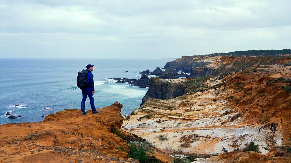
The fishermen's trail in Portugal is wild and adventurous: the Rota Vicentina long-distance hiking trail, as it is called in Portugal, winds its way along the historic fishermen's path along the rugged Atlantic coast, past spectacular cliffs, hidden sandy bays and crashing waves. As one of the most beautiful coastal hiking trails in Europe, it delights with unspoilt nature and maritime flair, leading over sandy dunes and rocky paths. In this article, you will find all the information you need for careful planning. I will introduce each stage in detail. The guide is supplemented by numerous highlights along the route and a complete overview of all accommodation and campsites.
Content
1. Journey
2. Route
3. Accommodation
4. Weather and best time to travel
5. Further information
6. Recommended stages
7. Packing list
8. GPX and map information
9. Conclusion
The Fishermen's Trail at a glance
Length: approx. 223 km (139 miles)
Most beautiful section: The most beautiful section is the 75 km in 4 stages from Porto Covo to Odeceixe (very popular)
Duration: 13 days for the entire Fishermen's Trail, depending on stage length, rest days and personal fitness, 4 days for the most beautiful section
Elevation: 2,200 metres in total, with frequent ups and downs along the cliffs
Difficulty: Technically easy. The biggest challenges are long sandy passages, wind, sun and heat. Sure-footedness on cliffs is required, but alpine experience is not necessary.
Landscape: Wild Atlantic coast, rugged cliffs, endless sandy beaches, dune landscapes, small fishing villages, pine forests and sweeping views across the ocean.
Highlights: The impressive cliffs along the entire trail, picturesque places such as Zambujeira do Mar and Almograve, stork nests and diverse bird watching, secluded bays and spectacular sunsets over the Atlantic.
Accommodation: Numerous guesthouses, hostels and hotels in coastal towns. Official campsites available. Wild camping is not permitted along the coast.
Best direction: North to south (e.g. Sines or Porto Covo → Lagos) recommended.
Requirements: Good basic fitness, resilience for sandy paths, sun protection, sufficient water. The trail is well marked and also suitable for less experienced long-distance hikers.
Official starting point: Is in Sines or Porto Covo is also very popular for the most beautiful section (starting in the north) or alternatively Lagos (starting in the south).
Trail markings: Very well marked with green and blue stripes (fishermen's trail). Navigation by map or GPS is still recommended.
Weather: Atlantic climate and usually very windy. Spring and autumn are considered the ideal times to travel. The summer months are often very hot and windless.

Getting to the Fishermen's Trail in Portugal
Getting to the Fishermen's Trail (Rota Vicentina) is straightforward and easy to plan. First, you should decide where you want to start your hike, as there are several popular starting points.
Overview of starting points:
Official starting point: Sines at the Trilho dos pescadores - North Trailhead
Popular short version (approx. 75 km): Porto Covo at Praia da Baía
Southern starting point: Lagos, directly at the train station
Getting there by plane
The nearest airports are Lisbon (LIS) and Faro (FAO).
Both are well suited for travelling to the Fishermen's Trail, as they have numerous international flight connections. Skyscanner is a recommended app for finding cheap flights and quickly comparing different offers.
Travelling by bus
In Lisbon, there is the Sete Rios bus station. From there, there are regular bus connections to numerous locations along the Fishermen's Trail. Providers such as Rede Expressos and FlixBus travel to Porto Covo, Sines and Lagos, among other destinations. The OMIO app is particularly useful for booking and route planning.
Travelling by train
If you want to start in the south, you can easily reach Lagos by train. There is also a direct train connection to Lagos from Faro. The OMIO app is also particularly useful for train travel.
As always, I recommend my video about the tour:
The Fisherman's Trail route in Portugal
The route is not particularly technically demanding. However, you should be in good physical condition, as the Fisherman's Trail often leads along sandy paths that make walking considerably more difficult. In total, you will cover either around 75 km on the most beautiful section between Porto Covo and Odeceixe or around 223 km on the entire route from Sines to Lagos.
There are only a few steep ascents and descents. No stage is longer than 23 km, and you never have to climb more than 350 metres ascent, which makes the hike very pleasant overall.
The route often runs directly along the cliffs, so sure-footedness is required. I did not find the route to be exposed and can assess this well with my experience of fear of heights.
In the summer months, the heat can be an additional challenge, as many sections offer little shade. I would advise against hiking in the summer months. You can find more information on this below in the section on difficulties and in my experience report.
Waymarking: The route is very well marked in both directions. The markings have the following meanings:


I recommend breathable gaiters for the sandy paths. Without gaiters, you will constantly have sand in your shoes.
Remember to insure your trip well – because a fall or other typical hiking injury can quickly result in high rescue costs. Auras Insurance offers you worldwide hiking and trekking insurance, specially designed for active travellers.
Use the discount code CJCOM to get 10% off your insurance.

The stages of the Fisherman's Trail in Portugal
The Fisherman's Trail in Portugal runs along the breathtaking Atlantic coast and is divided into several stages. Each of these stages offers unique landscapes, from spectacular cliffs to secluded beaches and picturesque fishing villages.
Most beautiful section: 75 km from Porto Covo to Odeceixe (very popular)
Stage 1: Porto Covo - Vila Nova de Milfontes (approx. 20 km and 100hm)
Stage 2: Vila Nova de Milfontes - Almograve (approx. 15 km and 100hm)
Stage 3: Almograve - Zambujeira do Mar (approx. 22 km and 170hm)
Stage 4: Zambujeira do Mar - Odeceixe (approx. 18 km and 250hm)
Classic:
Stage 1: Sines (São Torpes) - Porto Covo (10 km and 30 m ascent)
Stage 2: Porto Covo – Vila Nova de Milfontes (20 km and 100 m ascent)
Stage 3: Vila Nova de Milfontes – Almograve (15 km and 100 m ascent)
Stage 4: Almograve – Zambujeira do Mar (22 km and 170 m ascent)
Stage 5: Zambujeira do Mar – Odeceixe (18 km and 250 m ascent)
Stage 6: Odeceixe - Aljezur (23 km and 160 m ascent)
Stage 7: Aljezur – Arrifana (17 km and 230 m ascent)
Stage 8: Arrifana – Carrapateira (20 km and 280 m ascent)
Stage 9: Carrapateira – Vila do Bispo (15 km and 310 m ascent)
Stage 10: Vila do Bispo – Sagres (20 km and 120 m ascent)
Stage 11: Sagres – Salema (20 km and 350 m ascent)
Stage 12: Salema – Luz (11 km and 220 m ascent)
Stage 13: Luz – Lagos (11 km and 220 m ascent)

Accommodation for the Fisherman's Trail in Portugal
There is a wide range of accommodation along the Fisherman's Trail in Portugal, from cosy guesthouses and hotels to campsites. Many accommodations on the Rota Vicentina also offer sea views – perfect for enjoying the sunset after a long day of hiking.
Tip: At Booking.com, you often have the option of cancelling your accommodation free of charge up to 24 hours before arrival for a small surcharge.
You can book directly via these links on my partner platform ‘Booking.com’, it won't cost you a penny more. Thank you very much!
Sines (São Torpes): Starting point
Directly at the starting point: São Torpes by Campigir - $
Hotel Veleiro - $$
Casa da Estação - $
Stage 1: Porto Covo
Stage 2: Vila Nova de Milfontes
Stage 3: Almograve
Fishermens House - $
Stage 4: Zambujeira do Mar
Hakuna Matata - $ -
Stage 5: Odeceixe
AL-Odeceixe Verde - $$
Casa Morais - $
Hostel Seixe - $
Stage 6: Aljezur
Vicentina Hotel - $$
Casa Rocha Relax - $
Stage 7: Arrifana
Falésias da Arrifana - $$
Utopia - $
Natur Room - $$
Aljezur Villas - $
Stage 8: Carrapateira
Casa Fajara - $$$
Casa Luminosa - $
Casa Da Estela - $
Hostel do Mar - $
Stage 9: Vila do Bispo
Casa Mestre - $
Moinho Calmo - $$
CASA DIAS - $
Casa da Vila - $
Stage 10: Sagres
Residencia Julio - $
Kichershome - $
Stage 11: Salema
Stage 12: Luz
Stage 13: Lagos

Fishermen's Trail Portugal – Experiences & personal impressions
My experiences on the Fishermen's Trail in Portugal are as varied as the landscape itself. From spectacular cliffs and secluded beaches to challenging sandy paths. Here are my first-hand experiences and tips:
Getting there: The journey from Lisbon to Sines to the starting point at Trilho dos pescadores - North Trailhead was pleasant and uncomplicated. Right at the airport (arrival at 2 p.m.), I took a Bolt taxi and drove to the Sete Rios bus station. Alternatively, you can also take the bus. The journey takes only 16 minutes. The bus to Sines left at around 5 p.m. and took about two and a half hours. I had already booked my bus ticket online in advance via the OMIO app. Once I arrived in Sines, I spent my first night in a beautiful and inexpensive hotel – perhaps the perfect start to your adventure on the Fishermen's Trail!

Stage 1: Sines (São Torpes) - Porto Covo (10 km and 30 m ascent)
Sines exudes genuine Atlantic flair and is well worth a quick tour before you set off on your hike. In the charming historic old town, you can visit the Castelo de Sines. Also worth seeing are the old azulejo frescoes at the historic railway station, the Antiga Estação Ferroviária de Sines. At the harbour, you will find the Forte de Nossa and the small Chapela da Nossa, and if you have enough time, a visit to the Museum de Sines is recommended.
From the town centre, you walk about 6 kilometres to the official starting point of the Trilho dos pescadores - North Trailhead at São Torpes. This is where the fishermen's trail begins, right on the Atlantic coast. This increases the length of your stage to only 18 kilometres. Follow the wild coastline southwards on narrow paths and long sandy sections. The stage is ideal for arriving: flat, technically easy and characterised by beaches and dunes.
The Praia de Sao Torpes, the quiet Praia da Navalheira and the Praia de Porto Covinho are particularly beautiful. Shortly before Porto Covo, the terrain becomes increasingly rocky before you finally reach the charming coastal village with its white and blue houses. In Porto Covo, you will find several supermarkets, restaurants and numerous accommodations – perfect for a relaxed end to the first stage.
Tips for Porto Covo:
Stroll across the main square Jardim do Largo Marquês de Pombal
Dinner with typical Portuguese cuisine
Enjoy the sunset at Miradouro de Porto Covo
Relax at Praia Pequena
Discover rugged rock formations at Praia dos Buizinhos

Stage 2: Porto Covo – Vila Nova de Milfontes (20 km and 100 m ascent)
Start of the most beautiful section: If you only want to walk the most scenic part of the Fishermen's Trail, then start here. The popular 75 km variant to Odeceixe, divided into four stages, begins in Porto Covo.
Porto Covo is a charming fishing village with whitewashed houses and blue window frames. In the morning, you will already meet numerous hikers here, occasionally also surfers or dropouts who enjoy the relaxed life on the Atlantic coast. The relaxed atmosphere makes the place an ideal starting point for this stage.
Before you set off, you should stock up on provisions. Please note that most supermarkets do not open until 9:00 a.m. Good places to go are Meu Super Porto Covo and Mercado Municipal Porto Covo.
After a few kilometres, you will be immersed in a spectacular coastal landscape. The trail leads along soft sandy paths, secluded beaches and rugged cliffs. After crossing a long stretch of beach, you will reach the first viewpoints above Praia do Malhão. This is followed by two particularly beautiful bays: Praia do Burdo and Praia da Angra da Cerva, where, with a little luck, you can watch fishermen at work.
Shortly before Vila Nova de Milfontes, it is worth making a short detour to a shipwreck, which is located a little off the path. Right next to it is Praia do Carreiro da Fazenda – a perfect spot for a spectacular sunset. From the cliffs, you can look out over the Atlantic Ocean as the sun slowly sinks into the sea, bathing the coast in warm, golden light. After that, it's only a short walk to the village, where you can relax and end your day of hiking.
Tips for Vila Nova de Milfontes
Stroll through the historic old town
Walk along the promenade to the Arcanjo Statue
Relax at Praia De Vila Nova Milfontes
Visit the Forte de São Clemente
Discover Atelier Vincent


Stage 3: Vila Nova de Milfontes – Almograve (15 km and 100 m ascent)
As not all accommodation offers breakfast, I can highly recommend the small, quaint shop Paparoca Sandwicheira – ideal for both a relaxed breakfast and a cosy dinner.
As you continue your hike, you will cross the Rio Mira river either by ferry or over the bridge, which means a small detour. I opted for the route over the bridge, as the stage is slightly shorter overall. This also gives you a good impression of the place, and the path leads you through a beautiful, shady forest.
You then walk along sandy paths along Praia do Brejo Largo and on to the impressive cliffs of Praia da Foz dos Ouriços. With a little luck, you may spot ospreys or storks nesting on the cliffs. Shortly before Almograve, you will find a wide beach with high dunes – a real paradise for photography and quiet moments by the sea. In the village itself, you will find several cosy restaurants serving fresh fish and typical dishes from the Alentejo – perfect for ending your day of hiking on a delicious note.
Tip: For dessert, I can highly recommend the traditional Portuguese sweet Pastéis de Nata.
Tips for Almograve
Sunset at the Bar da Praia do Almograve
Visit to the Igreja de Almograve
Walk to Praia de Nossa Senhora
Extra tip: The small grocery store Mercearia Café Amanhecer offers a hearty breakfast from 6:30 a.m. the next morning – ideal for an early start on the next stage.

Stage 4: Almograve – Zambujeira do Mar (22 km and 170 m ascent)
From Almograve to Zambujeira do Mar, a particularly varied stage along the wild Atlantic coast awaits you. Shortly after setting off, you will find yourself immersed in a vast dune landscape, where the sand gives way beneath your feet and the wind carries the scent of pine trees and wild herbs. The trail continues over high cliffs with spectacular views of crashing waves and hidden coves.
An absolute highlight are the nesting sites of the white storks, which breed here directly on the steep rock faces – a rare and impressive natural spectacle. This section is one of the most beautiful of the entire Fisherman's Trail. The Praia da Barca Grande and Cavaleiro Beach are particularly impressive.
Tip: About halfway along the route, you will reach the small village of Cavaleiro. The Café Adília is the perfect place to take a well-deserved lunch break – ideal for recharging your batteries and enjoying the relaxed atmosphere. Afterwards, you will pass the Farol Cabo Sardão. Right next to it are the Passadiços do Cabo Sardão, where you can discover more stork nests. The terrain then becomes rockier again before you reach the remote Praia do Creleizão.
Small fishing villages along the way invite you to take short breaks – often with freshly caught fish. Shortly before Zambujeira do Mar, it is worth making a detour to Praia do Tonel. You will then reach one of the most beautiful coastal villages in the region, spectacularly built on the cliffs. In the local restaurants, you can round off the day with a delicious cataplana, freshly caught fish or grilled octopus.
Tips for Zambujeira do Mar
Sunset at this viewpoint
Walk along the promenade
Visit the Capela de Nossa Senhora do Mar
Enjoy freshly caught fish in one of the local restaurants
Food: In Zambujeira do Mar, you will find several supermarkets where you can stock up on supplies.
Because of the long sandy trails, I recommend comfortable and well-cushioned trail running shoes for this tour - Salomon Xa Pro 3D Gore-tex (available for men and women)
‘Give your woman the right shoes and she can conquer the world.’ Quote from Marilyn Monroe
Enjoy the following pictures in the slider:


Stage 5: Zambujeira do Mar – Odeceixe (18 km and 250 m ascent)
You start again on sandy paths along the cliffs, where small bays and rugged rock formations open up again and again. The path leads you through fragrant macchia with rosemary and wild thyme, while seagulls and ospreys circle above the Atlantic. Shortly after Zambujeira do Mar, it is worth making a detour to Praia dos Alteirinhos, where a small waterfall flows directly towards the beach – a surprising highlight.
The rest of the trail is characterised by rugged cliffs and is one of the most impressive sections of the Fisherman's Trail. In the small village of Azenha do Mar, you will find a beautifully situated restaurant with views of the cliffs and the vastness of the Atlantic Ocean – perfect for a relaxing lunch break. Then continue your hike through the Parque Natural do Sudoeste Alentejano e Costa Vicentina and follow the rocky coastal paths to Odeceixe.
Tip: For a particularly atmospheric sunset, I recommend this spot above the coast. Please note, however, that you will then have to walk about 5 kilometres along the road to Odeceixe – partly in twilight or darkness.
Tip: There is a laundrette in Odeceixe, ideal for freshening up your clothes during the tour.
Tips for Odeceixe
Dinner at Ao Largo Odeceixe (personal recommendation)
Visit the Moinho de Odeceixe (historic windmill)
Discover the Vodnjak fountain
Visit the Igreja de Odeceixe
Visit the Museu Adega de Odeceixe
Food: In Odeceixe, you will find several supermarkets where you can conveniently stock up on supplies.
For some hikers, this is where the most beautiful section of the Fisherman's Trail ends. From Odeceixe, regular bus services will take you back to Lisbon or Faro.

Stage 6: Odeceixe - Aljezur (23km and 160m ascent)
This stage gradually moves away from the Atlantic coast and takes you into the quieter, rural hinterland of the Algarve. From Odeceixe, you first walk leisurely along the Ribeira de Seixe, past green riverbanks, small gardens and agricultural land, which form a pleasant contrast to the rugged coastline. Soon you will reach the coastal village of Praia de Odeceixe, where you can see one of the stone sculptures of the ‘7 Maravilhas’. However, don't expect a spectacular wonder of the world here – it is more of a regional monument that fits in well with its surroundings.
This is immediately followed by a short, particularly beautiful section along the coast. The trail takes you past Quebrada Beach, a wide beach with an open view of the Atlantic Ocean. At Praia da Baía dos Tiros, you finally leave the coast behind – you won't see the sea again until the next day of hiking. Again and again, beautiful views of the Atlantic Ocean open up before you dive deeper into the interior.
The paths alternate between sandy trails, dirt roads and short asphalt passages, giving you an increasingly peaceful, almost secluded hiking experience. About halfway along the route, you will reach the small village of Rogil, where several restaurants and cafés offer a well-deserved break.
The closer you get to Aljezur, the more striking the imposing ruins of Aljezur Castle appear on the horizon, towering high above the village and one of the highlights of this stage. The historic village centre itself invites you to linger with its small cafés, restaurants and shops – perfect for recharging your batteries. Aljezur is also an excellent place to spend the night before continuing your hike along the Fisherman's Trail the next day.
Tips for Aljezur
Visit Castelo de Aljezur
Walk to Ponte de Aljezur

Stage 7: Aljezur - Arrifana (17 km and 230 m ascent)
Today's stage starts inland again. First, you walk parallel to the Ribeira de Aljezur and follow the river towards the coast until you finally reach the beautiful Praia da Amoreira. The small village of Praia de Monte Clérigo nestles charmingly against the rocky cliffs and is particularly inviting with its white houses and open view of the Atlantic Ocean.
From here, the terrain becomes rockier again and the typical high cliffs of the western Algarve begin. You will hike along the coast on narrow paths to the Ponta da Atalaia viewpoint, which offers impressive views over the sea. You will then leave the coast again and hike through the quieter hinterland towards Arrifana.
Tip: For a spectacular sunset, I can highly recommend the Fortaleza da Arrifana. Along the way, you will also find several restaurants that are ideal for a break or a relaxed dinner.
In Arrifana itself, there is another supermarket where you can stock up on supplies for the next stages of your hike.
Tips for Arrifana
Visit Arrifana Beach
Visit Fortaleza da Arrifana
Evening stroll along the promenade

Stage 8: Arrifana - Carrapateira (20 km and 280 m ascent)
Before heading back inland today, I recommend having breakfast in Arrifana right on the beach with a view of the sea. There are no places to stop for refreshments along the way this time, so you should bring enough food for lunch and an extra snack.
After a short section, you will reach the beautiful Praia do Canal. Take some time here to enjoy the crashing waves and towering cliffs. Then you leave the coast again and hike through the quieter hinterland. About halfway, you will reach the small village of Monte Novo. Unfortunately, there are no restaurants or special highlights here, so it is better to take a break along the way.
Shortly afterwards, you will return to the coast and reach the pretty Bordeira's beach. A viewing platform here offers beautiful views over the beach and dune landscape and invites you to take a short detour. Then follow the Ribeira da Carrapateira river for a while, which will eventually take you to Carrapateira.
Tips for Carrapteira
Sunset at this spot
As there is hardly any shade along the entire fishing trail and you are also exposed to the movement of the air all day long, I recommend my beloved ‘Piz Buin Mountain’ sun cream, as well as my ultra-light sun cap and wind blocker.
• Sun cap
"The sun also shines behind the clouds." Quote from Karl Friedrich Wilhelm Wander

Stage 9: Carrapateira - Vila do Bispo (15 km and 310 m ascent)
Today, you will continue your journey alternately along the coast and through the interior. You will reach the coast at the ruins of the former Islamic settlement of Islamic Settlement of Ponta do Castelo, a quiet, historic place with sweeping views of the Atlantic Ocean. You will then hike along several beautiful stretches of beach: first at the small Prainha, then at the expansive Praia do Amado and finally at Murração Beach.
After these impressive kilometres along the coast, you leave the sea behind again and continue through the peaceful hinterland towards Vila do Bispo. There are no places to stop for refreshments along the way, so you should take enough food and water with you for the day.
Tip: If you still have the energy and time, it is worth making a detour to the spectacular viewpoint of Cordoama. The view over the wide bay and the high cliffs is one of the most beautiful in the entire Algarve.
Tips for Vila do Bispo
Take a walk in the Jardim da Rua da Fonte park, followed by dinner

Stage 10: Vila do Bispo – Sagres (20 km and 120 m ascent)
Start as early as possible today, as there is much to discover in Sagres. In Vila do Bispo, you will find several supermarkets where you should stock up on food for today's stage. Although there are two restaurants along the way, there is no guarantee that they will be open.
The route initially takes you mainly through the quiet interior until you reach the coast again at Praia do Telheiro. From here, you will hike along the impressive cliffs for the last time in a southerly direction to the lighthouse at Cape Sao Vicente, the southwestern most point of mainland Europe. Be sure to take your time to explore the entire area – the rugged landscape, the cliffs and the view over the open Atlantic are particularly impressive.
Afterwards, the route continues mainly eastwards towards Sagres. Here you can experience the last, particularly beautiful sunset over the open Atlantic – a worthy conclusion to your hike along the Fishermen's Trail.
Tips for Sagres
Visit the Compass Rose
Sunset at the Lighthouse of the Town of Sagres
Walk to the Farol da Baleeira lighthouse

Stage 11: Sagres – Salema (20 km and 350 m ascent)
As this article is already quite extensive, I will deliberately keep the following stages brief for technical reasons. I will therefore only list the highlights that you should not miss under any circumstances.
Stage 12: Salema – Luz (11 km and 220 m ascent)
You can seriously consider combining stages 12 and 13. This will give you about 22 km and 440 m elevation gain, which is easily manageable. This will save you a day of hiking, which you can use for an extra stay in Lagos.
The rest of the route leads increasingly through tourist-oriented towns. The small towns appear well-kept and lively, but do not lose their scenic charm. Shortly after Salema, you should definitely make a detour to the Fortress São Luís de Almádena – a historic site worth seeing in a beautiful location.
Stage 13: Luz - Lagos (11km and 220m ascent)
After crossing the local mountain, a varied and scenically beautiful trail leads you to Lagos. There is much to discover along the way before your journey finally ends in one of the liveliest towns in the Algarve.
Be sure to take your time in Lagos. The town delights with its relaxed Mediterranean flair, street music, inviting cafés and pubs. It's best to stay for a day or two to explore everything at your leisure and enjoy the Portuguese way of life.
The main square in particular attracts many visitors with its street cafés, musicians and relaxed atmosphere. Here you can relax and enjoy life to the fullest. Your hike ends in a place that perfectly combines tranquillity and urban life.
You have reached your destination – congratulations! If you have completed this tour, you have my utmost respect. It was not an easy journey, but it was an unforgettably beautiful one. For me, the Fisherman's Trail is one of my absolute favourite tours.
Tips for Lagos

Best time to visit the Fisherman's Trail in Portugal
The best time to explore the Fisherman's Trail along the Portuguese coast is from February to May and from late September to November. During these months, temperatures are pleasant, the landscape is in bloom or ablaze with warm autumn colours, and the beaches are not crowded. In addition, there is often a fresh breeze from the Atlantic, which makes hiking particularly enjoyable.
The summer months of July and August, on the other hand, are very hot, and many sections run along sandy paths with no shade. I do not recommend hiking the Fisherman's Trail between mid-June and mid-September.
Please note: The weather in Portugal, especially on the coast, can be very changeable, particularly in spring and autumn. Strong winds or sudden rain are not uncommon. Therefore, pack light but weatherproof clothing and make sure you have adequate sun protection.

Rota Vicentina – further information about the Fishermen's Trail
Below, I have compiled some useful information about the Rota Vicentina for you.
Money: I was able to pay cashless everywhere. However, as always, I recommend taking some cash with you.
Mobile phone reception: I had continuous network coverage.
Food: There is a small supermarket in almost every fishing village.
Taxi: Bolt and Uber work well, but the waiting time can be long. In an emergency or in bad weather, you can easily skip a stage by taxi.
Luggage transfer: You can find it here!
Wild camping: This is prohibited along the entire trail. I saw a few rangers on my hike.
Water: There are hardly any water sources along the way. Occasionally, you will find public taps at designated parking areas for motorhomes, but I cannot guarantee their availability. I managed fine with 2 litres of water per day. The tap water is enriched with chlorine, which you can clearly taste. According to my research, it is drinkable, but it gave me mild heartburn. I can't say for sure whether it was actually the water, but I suspect it was. After three days, I switched to bottled water – after that, I no longer had heartburn.

Difficulty of the fisherman's trail portugal
The Fischerweg is a moderately difficult multi-day hike. Although no alpine skills are required, you should have a good basic level of fitness as many sections lead over sandy paths, which makes walking more difficult. There are repeated steep ascents and descents, but no sections secured by ropes.
Weather conditions: The weather on the coast can change quickly. Strong winds, fog or sudden temperature changes are possible. Pay attention to the forecasts and protect yourself from the sun, as many sections offer little shade. The wind can also be extreme, so behave accordingly and keep your distance from the cliffs. Also observe the correct behaviour during thunderstorms.
Caution: The heat can also be extreme in the low season. The reflective sandy landscape intensifies the sun's rays, which is why sufficient water and sun protection are essential.
Trail markings: The fishing trail is signposted throughout with the typical green-blue markings.
Children: Due to the challenging sandy passages and the proximity to steep cliffs, the hike is not recommended for small children. However, young people with hiking experience can manage the tour well.
To prepare yourself optimally for your hikes, I recommend the workouts on my YouTube channel.
Packing list for the Fisherman's Trail in Portugal
Here I recommend the most important hiking equipment that I own, have tested myself and have also bought myself. I pay a lot of attention to the weight and quality of my equipment. The equipment should simply feel good on longer tours and also be light. I can recommend the equipment for women because my wife uses it and it is basically the same as the equipment for men.
Note: Please keep in mind that the packing list is general and you will have to adapt it depending on the season and your needs!
Advertising note: These product links are affiliate links. If you buy something through one of these links, I will receive a small commission without you having to pay more. This is for the maintenance of my blog and you support me with my project, for which I am very grateful. Thank you very much!
Clothes
Hiking boots
Hiking shorts
Long hiking pants
Functional shirt
Hybridjacket
Fleece-jacket
Rain jacket
Functional underwear
Hiking socks
Other hiking equipment:
• Sun cap
Hiking backback (approx. 60 litres or as required)
by EXPED - unfortunately not available on Amazon.
• Backback - Ospray (was my old one and is also good)
Technology and orientation:
• Compass
• Headlamp
• GPS device or GPS watch if necessary
• Binoculars if necessary
Catering:
• Sweets to keep up morale :)
Health & first Aid:
• First Aid (small and light)
• Tape
• Bivouac
• Toilet paper
Other:
• Passport/Insurance certificate
• cash
• Gas cartridge
Film equipment:
• Camera
• Drone
• Tripod
• Clip

FAQ – Frequently asked questions about the Fisherman's Trail in Portugal
In this FAQ, you will find answers to questions about the difficulty, safety and important conditions for your hike on the Fisherman's Trail.
What is the Fisherman's Trail in Portugal?
The Fisherman's Trail is a historic coastal path along Portugal's wild Atlantic coast, which was formerly used by fishermen.
How difficult is the Fisherman's Trail?
The Fisherman's Trail is considered an easy to moderately difficult multi-day hike. Technical or alpine skills are not required, but a good level of fitness is important.
What are the trail conditions like on the Fisherman's Trail?
Many sections lead over deep, sandy ground, which makes walking significantly more strenuous. In addition, there are regular steep ascents and descents.
What are the weather conditions like along the Fischerweg?
The coastal weather can change quickly. Strong winds, fog and sudden temperature changes are possible. The wind in particular can be very strong.
Is there anything special I need to pay attention to in terms of the weather?
Yes. Check the weather forecast regularly, protect yourself from the sun and keep a safe distance from the cliffs in strong winds. You should also know what to do in the event of a thunderstorm.
Is the Fischerweg also hot in the off-season?
Yes. Even outside the high season, it can get very hot. The light-coloured sand reflects the sun strongly, which further intensifies the heat.
Is the Fisherman's Trail well marked?
The Fisherman's Trail is very well signposted throughout with the typical green and blue markings.
Is the Fisherman's Trail suitable for children?
The hike is not recommended for small children due to the strenuous sandy passages and proximity to steep cliffs. However, young people with appropriate hiking experience can easily manage the tour.
Where can I camp on the Fisherman's Trail?
Sines (starting point): Campigir São Torpes
Porto Covo: Camping Costa do Vizir or Campsite Porto Covo
Vila Nova de Milfontes: Campiférias
Almograve: no campsite available
Zambujeira do Mar: Camping Villa Park
Odeceixe: Camping São Miguel (approx. 1.5 km outside, in the neighbouring village)
Aljezur: Campsite Serrão
Arrifana: no campsite available
Carrapateira: no campsite available
Vila do Bispo: no campsite available
Sagres: Campsite & Bungalows Sagres Orbitur
Salema: Salema Eco Camp – Surf & Nature
Luz: Orbitur Campsite Valverde
Lagos (destination): Parque de Campismo da Trindade

Fisherman's trail gpx
The GPX files are available for download from the following providers.
Outdooractive: https://out.ac/3wXBOZ
Fisherman's trail best part
One of the most beautiful stages of the Fishermen's Trail leads from Zambujeira do Mar to Odeceixe. Spectacular cliffs, secluded sandy bays and the picturesque natural harbour of Azenha do Mar make this section particularly impressive. The highlight: the view of the impressive estuary of the Rio Seixe, where the sea and river landscape merge.

Fishing trail with tent
Camping along the fishing trail in Portugal is a special adventure and allows you to experience nature up close. Official campsites offer safe accommodation, while wild camping is prohibited in Portugal.
I have listed the best options for you below:
Starting point in Sines: Campigir São Torpes
Porto Covo: Camping Costa do Vizir or Campsite Porto Covo
Vila Nova de Milfontes: Campiférias
Almograve: No campsite available!
Zambujeira do Mar: Camping Villa Park
Odeceixe: Camping São Miguel
Aljezur: Campsite Serrão
Arrifana: No campsite available!
Carrapateira: No campsite available!
Vila do Bispo: No campsite available!
Salema: SALEMA ECO CAMP - SURF & NATURE

Conclusion on the Fisherman's Trail in Portugal
The Fisherman's Trail in Portugal is one of the most impressive coastal walks in Europe. Along the wild Atlantic coast, spectacular cliffs, secluded bays and historic fishing trails await you, deeply embedded in the landscape and history of the region. As part of the Rota Vicentina, the Fisherman's Trail combines magnificent stages with charming villages, wide sandy paths and ever-changing views of the ocean. If you want to hike the Fisherman's Trail in Portugal, you should book your accommodation well in advance, as the trail is very popular, especially in the high season.
As always, I would be delighted to receive feedback via one of my channels.
You are also welcome to leave me a comment here.

Hello, I am Christian, the chief globetrotter of this Site and an enthusiastic adventurer, hiker and filmmaker. I love to explore new paths and inspire people with them, and I love to share my hiking knowledge with you! You can also find my videos on YouTube! On my blog you can find tips for beginners and professionals on the greatest and most beautiful hiking tours there are. I want to encourage people to explore the world as a hiker, whether in the countryside, through the forest or in the mountains. True to the motto: If you haven't hiked, you haven't seen the world,
On my blog, I also write about hiking gear, the right summit training and nature conservation, as well as tips and information about hiking.


perfect