South Hams Way - Guide, accommodations, and stages
- Oct 10, 2025
- 22 min read
The South Hams Way is a spectacular 163 km circular hike through four different landscapes in the south of England. In this article, you will find all the information you need to plan your trip. I will introduce you to each stage in detail, with lots of highlights and all the accommodation options. This way, you will have all the information you need for your trip—and you can plan your hike easily and specifically.

Content
1. Journey
2. Route
3. Accommodation
4. Weather and best time to travel
5. Further information
6. Recommended stages
7. Packing list
8. GPX and map information
9. Conclusion
South Hams Way
The South Hams Way is a circular hiking trail in southwest England, covering approximately 163 km through the South Hams area of Devon. The trail is divided into 10 stages, each between approximately 12 and 22 kilometers long.
The trail leads through wild moorland, rolling hills, extensive coastal sections, river valleys, estuaries, and floodplains.
The highest point is 390 m above sea level, which means that the route mostly winds gently through the landscape.

Getting to the South Hams Way
Getting to the South Hams Way is easy and can be done by public transport. The starting point is in Totnes.
Airplane: The nearest airport is Exeter Airport (EXT), but you can also fly to Bristol (BRS) or London Heathrow (LHR). To find cheap flights, I highly recommend Skyscanner—a first-class app that gives you a quick overview of the best flight deals.
Train: Totnes is located directly on the main line between London Paddington and Penzance. Trains run hourly from London Paddington, and the journey takes about 2.5 to 3 hours. There are also direct connections to Totnes from Bristol, Exeter, or Plymouth. It's best to book your ticket in advance via Trainline or directly with GWR (Great Western Railway) or the OMIO app.
Bus: There are regular buses (Stagecoach, National Express) between Exeter, Totnes, Dartmouth, and other coastal towns. Especially in summer, it is advisable to reserve a seat. You can easily find timetables via Traveline South West, the Stagecoach app, or the OMIO app.
Return journey: As the South Hams Way is a circular route, you will return to Totnes at the end. From there, you can easily take the train back to Exeter, Bristol, or London. If you are only walking a few stages, you can also return by bus or boat from coastal towns such as Salcombe or Dartmouth.

South Hams Way route
The South Hams Way is divided into 10 easily manageable stages. Depending on the section, the trail is mostly secluded and wild—usually technically easy (difficulty level T1), only rarely (T2).
Waymarkings: The South Hams Way is well signposted. Along the route, you will find green signposts with the South Hams Way logo (white walker on a green arrow). On the coastal sections, the markings are sometimes supplemented by the symbols of the South West Coast Path.

Remember to insure your trip well – because a fall or other typical hiking injury can quickly result in high rescue costs. Auras Insurance offers you worldwide hiking and trekking insurance, specially designed for active travellers.
Use the discount code HIKINGFEX to get 10% off your insurance.

South Hams Way stages
The South Hams Way in England follows breathtaking trails and is divided into several stages. Each stage offers unique landscapes, from spectacular cliffs and secluded beaches to picturesque fishing villages. Below are the official stages of the South Hams Way:
South Hams Way classic in 10 stages:
Stage 1: Totnes - Buckfastleigh (11km and 210m ascent)
Stage 2: Buckfastleigh - South Brent (15km and 390m ascent)
Stage 3: South Brent - Ivybridge (12km and 320m ascent)
Stage 4: Ivybridge - Newton Ferres (19km and 310m ascent)
Stage 5: Newton Ferrers - Mothecombe (16km and 280m ascent)
Stage 6: Mothecombe - Hope (17km and 310m ascent)
Stage 7: Hope - Salcombe (13km and 310m ascent)
Stage 8: Salcombe - Torcross (21km and 400m ascent)
Stage 9: Torcross - Darthmouth (18km and 480m ascent)
Stage 10: Darthmouth - Totnes (21km and 530m ascent)
Outdooractive: https://out.ac/3xZ7TT

South Hams Way Accommodation
There is a wide range of accommodation available along the South Hams Way, from cosy guesthouses and hotels to campsites. You can book directly via the following links on my partner platform Booking.com – at no extra cost to you. As always, the earlier you book, the cheaper the prices. For a small surcharge, you can also cancel most accommodations free of charge in case of emergency.
Starting point: Totnes
Stage 1: Buckfastleigh
Stage 2: South Brent
Stage 3: Ivybridge
Stage 4: Newton Ferrers
Stage 5: Mothecombe
Stage 6: Hope
Stage 7: Salcombe
Stage 8: Torcross
Stage 9: Dartmouth
Stage 10: Totnes
South Hams Way Guide
This guide to the South Hams Way gives you an overview of each stage and tells you what to expect on your upcoming tour. I have listed all the highlights that await you along the way and at the end of each stage.
Getting there: Getting to Totnes, the starting point of the South Hams Way, is easy. The best option is to fly to London – a centrally located airport with numerous connections from all over Europe. From there, you can easily reach Totnes by train in about 3 hours. Once you arrive in Totnes, we recommend staying overnight in a charming bed and breakfast – including a traditional English breakfast the next morning. The perfect start to your hike along the South Hams Way.
Places of interest for the evening in Totnes:
Totnes Castle
Totnes Museum
Totnes Peak
Leechwell Garden
Longmarsh in Totnes
Totnes Cinema
Stage 1: Totnes – Buckfastleigh (11 km, 210 m ascent)
The first stage begins in the pretty Borough Park in Totnes. From here, follow the path through Totnes to Dartington Estate.
Note: If Dartington Estate is closed for any reason, e.g. due to forestry work, you will need to take an alternative route. It is best to use your online map material for this.
Tip: Dartington Estate is a historic destination with Dartington Abbey, the Barn Cinema, cosy cafés, The White Hart bar and restaurant, and well-tended gardens.
Then follow the path to the Long Trail, which is marked by a sign. After that, you will enter North Wood, which you will cross on narrow, sometimes root-covered paths – a particularly beautiful section through dense forest.
Tip: Shortly before you reach Staverton Bridge, you have the opportunity to visit the beautiful St. Mary's Church. To do so, follow the path through North Wood to the church on Upper Drive.
You will then pass Staverton railway station, where you will find a buffet car café, outdoor seating and – depending on the season – open toilets.
From here, continue along beautiful paths towards Landscove and Woolston Green.
Tip: The Riverford Kitchen restaurant is nearby – a great place to stop for refreshments along the way.
The path now becomes very uneven as it climbs up the hillside – with ruts, mud, water and numerous tree roots – until you reach a metal gate leading to a field. Continue along this path. Soon you will have a wide view of Buckfastleigh and Dartmoor in the distance.
After passing through another metal gate marking the boundary of the forest, continue to a footbridge. Follow the path signposted Public Footpath straight ahead downhill through the forest.
Caution: The path is steep and can be very slippery in wet weather – take extra care when crossing the road.
Then follow the path to the bridge, built in 1749, and finally to Buckfastleigh, your destination for today.
Tip: To round off the day, I recommend a visit to one of the few but cosy pubs in Buckfastleigh.
Tip: In Buckfastleigh, you can also:
watch the historic trains at South Devon Railway Station,
visit the South Devon Railway Museum or
explore the Valiant Soldier Museum, a former Victorian pub with an exciting history.

Stage 2: Buckfastleigh – South Brent (15 km and 390 m ascent)
You leave Buckfastleigh via Merryfield Road until you reach a bridge and enter the adjacent forest. The path runs parallel to a stream and leads you on to Button Farm.
Then follow the path and climb a hill. Once at the top, you will get your first impressive view of Dartmoor. Enjoy the magnificent view in all directions – a real highlight of the stage.
Then cross another section of forest at Water Oak Corner, your next stage destination. Behind a gate, the path becomes much narrower and rockier, leading you into a wooded gorge where you have to cross a stream.
Continue through another gate, which leads you onto open moorland. An old sign at the gate indicates that you are now on Abbots Way.
Please note: There are no trail markers on the moor.
Several paths lead across the moor, but they all converge again at the top of the hill. You will now see the Avon Reservoir ahead of you.
Descend and follow the shore of the reservoir to the dam. It was built in 1957 to supply drinking water to the communities in South Devon.
The path continues along the river – past the ruins of Brent Moor House and two archaeological sites – to the first river crossing.
Tip: It is worth making a detour up to Shipley Tor, a magnificent viewpoint with a great panorama.
Continue to Shipley Bridge, where you will find an information board, toilets, picnic tables and occasionally a mobile café.
Then follow the path to Didworthy and past Lutton. Finally, you will reach your destination for the day: the idyllic village of South Brent.
Tips for South Brent:
Stroll along the River Avon
Visit the picturesque Lydia Bridge
Discover St Petroc's Church
Stroll across the small bridge to the pretty Brent Island nature reserve – highly recommended!
There are also a few bars that are worth a visit and are a great place to end the day.
As there is little shade along the entire South Hams Way and you will be exposed to the wind all day, I recommend my beloved ‘Piz Buin Mountain’ sun cream.
"The sun also shines behind the clouds." Quote from Karl Friedrich Wilhelm Wander

Stage 3: South Brent - Ivybridge (12km and 320m ascent)
Today, you will continue over Lydia Bridge – the small waterfall there is particularly charming and a lovely way to start the day.
Then follow the Dartmoor Way towards Great Aish. On the way, you can already see Ugborough Beacon in the distance – a mighty hill that you will cross later. The path continues until it finally turns into a road.
Follow this road uphill for about 350 metres until you reach a gate on the right-hand side that leads to the open moor – the Peek Moor Gate.
Go through the gate, slightly uphill, and then keep to the stone wall. Continue climbing until you reach the distinctive granite rock that marks the summit of Ugborough Beacon. From here, you can enjoy a fantastic panoramic view – of the vast moorland to the north and the lovely countryside of the South Hams to the south.
Continue south along the path. On your left, you will see Moorhaven – now a large, prestigious residential estate, but originally a psychiatric hospital that closed in 1992.
Tip: Just a few minutes' walk away, it is worth making a detour to Butterdon Hill (367 m), from where you can enjoy a magnificent view.
Then follow the Redlake Tramway, a wide track with a solid surface. It was completed in 1912 and was used to transport men and materials by steam train to the clay works in Red Lake and the drying sheds in Cantrell.
A little later, you will see the roofs of the town of Ivybridge – your destination for today on the South Hams Way.
Tip: It's worth visiting Ivybridge Rugby Club – with a bit of luck, you can watch an exciting rugby match there.
Tip: Also visit The Watermark, a community centre opened in 2008 with a public library, café, toilets, event rooms, cinema and offices.
Tip: The adjacent Longtimber Wood is well worth seeing. From there, you can take a lovely walk along the River Erme – continuing on to Victoria Park and St John's Church Hall. There are numerous places to stop for refreshments along the river.
Tip: Just outside Ivybridge is the idyllic Filham Park with its enchanting lakes – it's definitely worth a walk there.

Stage 4: Ivybridge - Newton Ferres (19km and 310m ascent)
Today's stage takes you to the coast. The best place to start is at the Watermark Centre in Ivybridge and follow the signs for the Erme-Plym Trail.
Soon you will catch your first glimpse of the striking Ermington Church with its crooked spire and the village of Ermington. Follow the road to Ermington, where you can take your first break.
Tip: The church in Ermington is well worth seeing – it's worth stopping off for a quick visit.
The South Hams Way itself bypasses the village, so you'll need to make a short detour to visit Ermington.
As you continue on your way, take care when crossing the busy roads.
After a while, you will see the towers of Flete Castle above the fields on your left.
Tip: It's worth making a short detour here too – the grounds are very picturesque.
The path then leads you through varied countryside – mostly fields – to the small, quiet village of Dunstone.
Tip: In Dunstone, you can visit a horse farm – a lovely stopover, especially for animal lovers.
You will then reach the River Yealm, and the path leads idyllically along the water to Yealmpton. Here you can plan a longer break.
Tip: Be sure to visit St. Bartholomew's Church. The surrounding grounds, including the old cemetery, are also well worth seeing and invite you to linger.
Further along the path, you will reach a crossing that leads to a country road.
Please note: The first part of the crossing is made of wood, followed by an old stone section. There are no handrails, and the crossing leads directly onto the country road. Therefore, special caution is advised, especially in wet weather.
Then follow the path to Newton Ferrers. There you will find accommodation, cosy pubs and good restaurants – ideal for relaxing after the stage.
Tip: An evening walk along Newton Creek is highly recommended – especially at sunset, when it is a real highlight.
Tip: Be sure to visit St. Peter's Church in the south or Holy Cross Church in the north of the village – both are architecturally and historically very interesting.

Stage 5: Newton Ferrers - Mothecombe (16km and 280m ascent)
Start your day and follow the route with the stream on your right. After a short while, you will reach a road – use the accompanying path there so that you don't have to walk directly on the road.
Soon, Newton Creek flows into the Yealm River. Continue to follow the signposted path here.
From here, the South Hams Way runs along the famous South West Coast Path to Dartmouth.
The path leads over a headland with beautiful views to the west of Rame Head (Cornwall), the striking Mewstone and Saint Werburgh's Church in Wembury.
Tip: About halfway along the coastal path, it is worth taking a look at the ruins of St Peter the Poor Fisherman's Church – a historic place with a special atmosphere.
A little further on, you will pass the beautiful Wadham Rocks Beach – ideal for a short break.
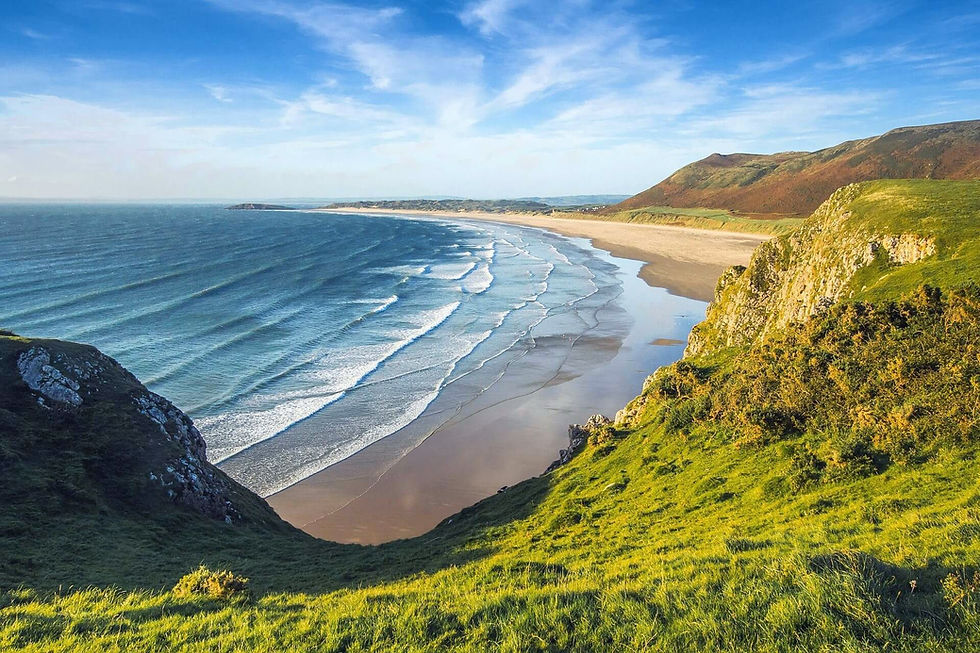
Shortly before reaching today's destination, you will arrive at the impressive Mothecombe Beach, which offers a unique atmosphere, especially in the evening hours.
Tip: In Mothecombe, it is worth visiting the well-kept Mothecombe Gardens. Right next door you will find the stylish restaurant ‘Schoolhouse Devon’ – perfect for a relaxed end to the day.
Please note: At the slipway, you can only cross the River Erme about an hour before and after low tide to reach the Wonwell slipway on the east side. Be sure to read the tide tables carefully before crossing the river.
Tide times for Mothecombe Beach – Erme estuary
If the tides do not allow you to cross the River Erme, unfortunately there is no way to bypass the river on foot – there is no suitable footpath away from the road and no ferry service.
In this case, you can call a taxi to take you to Wonwell by road.
Accommodation: The best places to stay are in nearby Kingston on the east side of the River Erme.

Stage 6: Mothecombe - Hope (17 km and 310m ascent)
Follow the South Hams Way along the coast from Wonwell Beach.
Tip: Right at the start, you will find the sights of Maltehouse Point and Ledner Sands.
Further along the coastal path, you will find some of the most beautiful sections, which I have listed here:
Pitt Cove
Wyscombe Beach
Ayrmer Cove
Ayrmer Cove Pikes
About halfway along the route, you will reach Bigbury-on-Sea. There you will find Bigbury Beach and a lovely café where you can take a long break.
Tip: At low tide, you can walk across the sand to the island. When the sea covers the sand, a ‘sea tractor’ connects the mainland with the hotel and the inn. Felicity Bay is also beautiful and accessible via a hiking trail.
Ferry: Then go to Cockleridge Ham and turn right at the ferry landing stage. This operates seasonally from 1 April to 30 September, daily from 10 a.m. to 12 p.m. and from 2 p.m. to 4 p.m. The ferry can be stopped from either side of the river.
If the ferry is not available, you can walk inland on the west side of the River Avon to Aveton Gifford and then continue on the east side to Bantham. Follow the signs to the Avon Estuary Walk.
Tip: Search for the file ‘Avon-Estuary-walk.pdf’ for more details. Part of the route leads inland (north) via a tidal road, which requires a detour of about 1.5 km at high tide.
Once you arrive in Bantham, follow the coastal path again. It becomes more rugged here and is definitely worth seeing.
Before you reach Hope, you will pass the following sights:
Broad Sand
Leasfoot Beach
South Milton Sands
National Trust – South Milton Sands
Visible in the distance: the striking Thurlestone Rock
Then follow the coastal path to your destination for the day, the picturesque village of Inner Hope with its characteristic thatched cottages.
Sights at Hope Cove:
St Clements Church, Hope Cove
Hope Cove Breakwater
Holy Trinity Church, Galmpton
Tip: Be sure to watch the sunset at Hope Sunset Cove – a real highlight.
Tip: I recommend the Lobster Pod Bistro, which is well worth a visit – ideal for an enjoyable evening.

Stage 7: Hope - Salcombe (13km and 310m ascent)
From Hope, follow the coastal path through the woods to the open fields.
Tip: There you will come directly to the first sightseeing spot called Bolt Tail with its Iron Age fort. The area belongs to the National Trust, which maintains and manages it.
Then continue your way through the Bolberry Down conservation area.
Parkrun: Every Saturday morning at 9 a.m. throughout the year, Bolberry Down hosts the Parkrun – a popular running event for locals and visitors alike.
Your route continues downhill on the coastal path to Soar Mill Cove. The steep descent is rocky and partly covered with loose stones, so caution is advised.
At Soar Mill Cove, cross a bridge over a stream and go through a gate. Then follow the coastal path slightly uphill to the right.
This section is steep, rocky and partly rugged – you should definitely have a head for heights here.
Then continue on to Jubilee Pier (ferry terminal). From here, the pedestrian ferry will take you across the water to the starting point of the next section in East Portlemouth. Please check the current ferry times from Salcombe to East Portlemouth in advance.
Sights near Salcombe:
Salcombe Castle
Salcombe North Sands
South Sands Beach
Salcombe Maritime Museum
Holy Trinity Church Salcombe

Stage 8: Salcombe - Torcross (21km and 400m ascent)
Follow the coastal path to Gara Rock. Along the way, you will pass beautiful viewpoints. At Gara Rock, there is also a lovely sandy beach that you can visit.
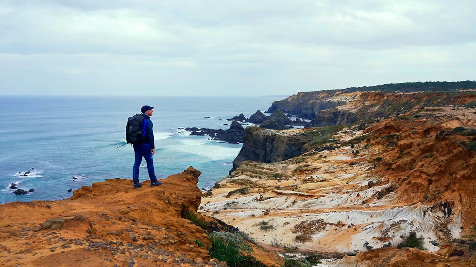
From Rickham Sands, continue along the coastal path towards Prawle Point. This section is rocky, narrow and steep. You will pass Maceley Cove, which can be reached via a steep path.
Continue past the NCI Coastwatch Station at Prawle Point.
Tip: If the station is open, you can take a tour and also visit the visitor centre.
In the village of East Prawle, you will find a number of facilities such as a seasonal shop, a pub, toilets, car parks and accommodation, including campsites.
After the National Trust car park, follow the coastal path eastwards. Right at the start of this section, on the right-hand side of the path, there is a World War II bunker.
Continue to Horseley Cove, a rocky beach, and past Maelcombe House. The path is rocky in places here.
You can then enjoy a beautiful view all the way to Dartmouth.
Tip: It is worth making a detour downhill to visit the lighthouse at Start Point. Start Point Lighthouse is open to visitors on certain days.
As you continue on your way, you will pass coastal defences between the houses. Eventually, you will reach Torcross, your destination for the day. In the evening, I recommend a walk on the beach and a visit to one of the two local pubs.
Tip: In Torcross, there is a Sherman tank that was salvaged from the sea in 1984. It serves as a memorial to the many US soldiers who lost their lives in April 1944 during Exercise Tiger in preparation for D-Day.
At the far end of the Torcross car park is a public birdwatching station overlooking Slapton Ley Lake, which is part of the Slapton Ley Nature Reserve.


Stage 9: Torcross – Dartmouth (18 km and 480 m ascent)
Leave the car park in Torcross and follow the path along the lake (Ley), parallel to the road. This is the so-called ‘Slapton Line’, a gravel ridge on which the busy A379 runs and which separates the sea from the freshwater lake.
Along the way, you will pass beautiful beaches such as Strete Gate and Blackpool Sands. After about 3 km, the coastal path follows an uphill climb. Behind you, magnificent views of the coastline open up.
Finally, you will reach the village of Strete, which invites you to linger with its pub and shop.
Further along the way, three beautiful beaches await you, including Compass Cove Beach and Sugary Cove Beach.
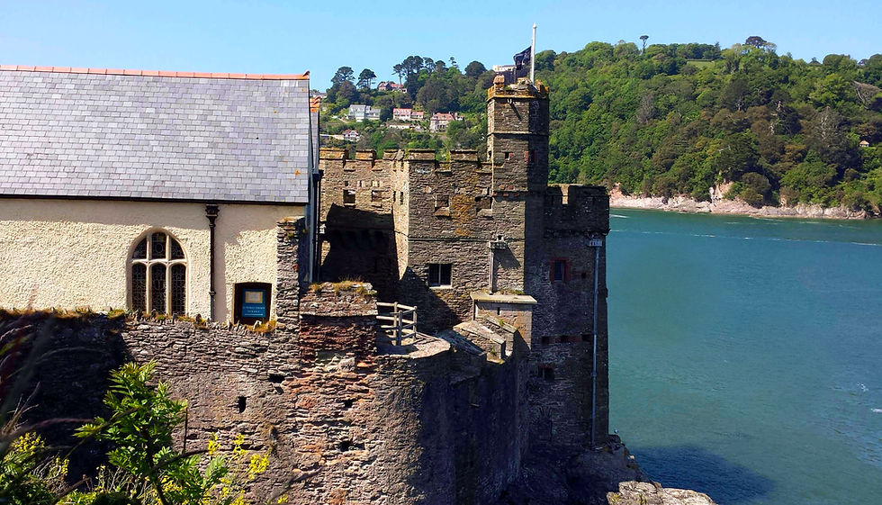
Tip: Afterwards, visit the impressive Dartmouth Castle and the adjacent St. Petrox Church. The entire area is well worth seeing.
Tip: From there, you can also reach the Gallants Bower hiking area with its beautiful flower meadows in the middle of the forest.
Tip: From a distance, you may also be able to spot the sculpture Miranda, Mermaid of Dartmouth – a mermaid sitting on a rock. However, it is not easy to find!
Finally, you will reach the extremely beautiful Dartmouth. The town centre offers a variety of shops, cafés, restaurants and hotels. I recommend taking a relaxing evening stroll there.
The following sights can be discovered in Dartmouth:
Bayard's Cove Fort
Bayard's Cove
Bayside Cannon Dartmouth
View Point next to the Boathouse
Dart Gallery
Dartmouth Museum
The Flavel Arts Centre
Simon Drew
Studio Dix Neuf
Royal Avenue Gardens with the Victorian Jubilee Fountain
Flavel Church
St Saviour's Church

Stage 10: Dartmouth – Totnes (21 km and 530 m ascent)
Today, you will return inland along a riverside footpath to your starting point and the end of your hike. Start very early, as the route is long and there is quite a bit of elevation gain to overcome. Follow the trail markers or your GPS device and follow the route from Dartmouth to Dittisham.
Tip: Take a look at St George's Church in Dittisham – you'll pass right by it.
Tip: About 1 kilometre after Dittisham, you can visit Coombe Farm Studios, which are also right on the trail.
Your route continues to Ashprington.
Before that, you will reach the village of Cornworthy. The church is on the right-hand side. The tower of St Peter's Church in Cornworthy has three floors, a style unique to Devon. The church has a beautiful rood screen, a Georgian pulpit and a Norman baptismal font. You can also visit Cornworthy Priory, an ancient architectural site.
Cornworthy and Ashprington are a good place to take a longer break, as this point is roughly halfway along the route. Please note, however, that there are few places to stop for refreshments there.
Finally, you reach Ashprington.
Ashprington developed as a farm village for Sharpham House, and many of the houses feature similar architecture with diamond-shaped window panes. The Durant Arms Pub was named after Richard Durant, a 19th-century landowner who was known for fining his tenants for using profanity.
Tip: The village is home to the 14th-century St David's Church with a beautiful lychgate entrance and a charming church garden.
Tip: Further along the way to Ashprington, Sharpham House and its 550-acre estate are located on a headland on the right-hand side. The estate includes a Heritage Trail that describes points of interest along the route.
The rest of the route can be muddy when it rains heavily.
Finally, you will reach your destination for the day in Totnes. If you've made it – congratulations!
Tip: The South Devon Railway station with steam locomotives is nearby. From here, historic trains run via Staverton to Buckfastleigh.

To prepare yourself optimally for your hikes, I recommend the workouts on my YouTube channel.
South Hams Way – Best time to travel
If you want to explore the breathtaking coastal landscape of the South Hams in Devon, I would say that the months from May to October are particularly suitable. This is when southern England is at its most beautiful.
In spring, especially in April and May, the hedges and meadows bloom in all colours – from the bright yellow of the gorse bushes to the delicate white and pink tones of the fruit trees. The air is fresh and clear, and you often have the paths almost to yourself.
In autumn, the landscape is transformed into a play of warm colours – the foliage glows in shades of gold and copper, the sea appears deep blue, and the sunsets bathe the coast in a soft, golden light. It is a quieter time, ideal for those who want to enjoy nature in peace and quiet.

Beware of coastal weather!
The climate is usually harsh: the weather can change quickly on the South Hams Way. Strong winds are common in spring and autumn, and short, intense rain showers are not uncommon.
So here's my tip: Be sure to pack light but weatherproof clothing:
a breathable rain poncho that won't flap around in a storm,
a windbreaker, ideally with a hood – good quality ones are available for men and women,
and good sun protection, especially in summer, but also when it's cloudy – UV radiation on the coast should not be underestimated.
I would highly recommend a breathable rain poncho

South Hams Way – further information
Below, I have compiled some useful information about the South Hams Way for you.
Money: Cashless payments are widely accepted. However, as always, I recommend taking some cash with you.
Wild camping: This is prohibited along the entire trail.
Food: There are places to buy food and drink at the end of each stage.
Taxi: Bolt and Uber are not always available. In an emergency, you will have to use local taxis.
Water: There are not always water sources along the way. It is best to take 2 litres with you from your accommodation.

South Hams Way packing list
Here I recommend the most important hiking equipment that I own, have tested myself and have also bought myself. I pay a lot of attention to the weight and quality of my equipment. The equipment should simply feel good on longer tours and also be light. I can recommend the equipment for women because my wife uses it and it is basically the same as the equipment for men.
Note: Please keep in mind that the packing list is general and you will have to adapt it depending on the season and your needs!
Advertising note: These product links are affiliate links. If you buy something through one of these links, I will receive a small commission without you having to pay more. This is for the maintenance of my blog and you support me with my project, for which I am very grateful. Thank you very much!
Clothes
Hiking boots
Hiking shorts
Long hiking pants
Functional shirt
Hybridjacket
Fleece-jacket
Rain jacket
Functional underwear
Hiking socks
Other hiking equipment:
• Sun cap
Hiking backback (approx. 60 litres or as required)
by EXPED - unfortunately not available on Amazon.
• Backback - Ospray (was my old one and is also good)
Technology and orientation:
• Compass
• Headlamp
• GPS device or GPS watch if necessary
• Binoculars if necessary
Catering:
• Sweets to keep up morale :)
Health & first Aid:
• First Aid (small and light)
• Tape
• Bivouac
• Toilet paper
Other:
• Passport/Insurance certificate
• cash
• Gas cartridge
Film equipment:
• Camera
• Drone
• Tripod
• Clip

South Hams Way GPX
The GPX files are available for download from the following providers.
Outdooractive: https://out.ac/3xZ7TT

South Hams Way – Conclusion
The South Hams Way is much more than just a hiking trail – it is an invitation to discover the quiet beauty of southern England in all its facets. Between dramatic cliffs, rolling hills and charming coastal villages, a landscape unfolds that inspires and brings peace. Whether in sunshine, fog or wind, every step along this trail tells a story of nature, history and the unique atmosphere of Devon. Those who enjoy getting away from the crowds and seek authenticity will love the South Hams Way – and are guaranteed to return.
As always, I would be delighted to receive feedback via one of my channels.
You are also welcome to leave me a comment here.

Hello, I am Christian, the chief globetrotter of this Site and an enthusiastic adventurer, hiker and filmmaker. I love to explore new paths and inspire people with them, and I love to share my hiking knowledge with you! You can also find my videos on YouTube! On my blog you can find tips for beginners and professionals on the greatest and most beautiful hiking tours there are. I want to encourage people to explore the world as a hiker, whether in the countryside, through the forest or in the mountains. True to the motto: If you haven't hiked, you haven't seen the world,
On my blog, I also write about hiking gear, the right summit training and nature conservation, as well as tips and information about hiking.


Comments