GR131: 185 km tenerife trekking (+guide and GPX)
- Oct 30, 2023
- 15 min read
Updated: Apr 10
GR131 Trekking on tenerife is wild and adventurous: This natural jewel impresses with a fascinating variety of landscapes: lush jungle, barren volcanic landscapes, Spain's highest mountain, breathtaking mountain panoramas, idyllic sandy beaches and magically blooming laurel forests invite you to explore. This varied natural scenery makes the GR131 an absolute paradise for hikers. In 8 to 10 days, the trail leads across the entire island and takes in all the major highlights of the region. I thought this hiking trail on tenerife was fantastic - chapeau!

Contents
1. Arrival
2. Route
3. Accommodation
4. Weather and best time to travel
5. Further information
6. Recommended stages
7. Packing list
8. GPX and map information
9. Conclusion
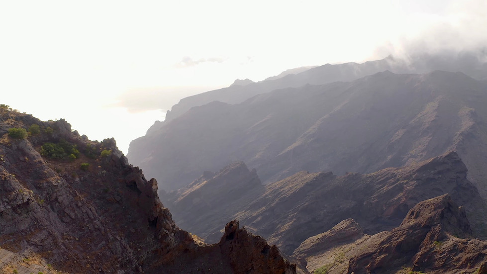
GR131: hiking trail tenerife
This diverse hiking and trekking trail largely follows the GR 131, but adds some spectacular highlights along the way. You'll summit Pico del Teide at 3,718 meters, as well as Pico Viejo and Pico Sur, traverse the otherworldly lunar landscape near Vilaflor, and explore the lush Anaga Mountains. Overnight stays alternate between cozy apartments or hotels, rustic huts, and official campsites where you'll pitch your tent. The best part? This adventure can be undertaken virtually year-round.

Hiking trail tenerife arrival
Flight: It is best to book a flight to one of the two airports on Tenerife - either in the north or south of the island. The starting point of the tour is in the small mountain village of El Morro, right next to the church. There are several ways to reach the starting point of the tour. I highly recommend using Skyscanner to find cheap flights – it's a great app that gives you a quick overview of the best flight deals. Here you will find an overview of all the relevant airports for your journey.
Bus: Tenerife has an excellent public transport network, which I can highly recommend. The bus line 416 goes to El Morro. I highly recommend the OMIO app for booking bus and train tickets.
Car: Alternatively, you can hire a car or take a taxi to get to the starting point in comfort.
Gas cartridge: There are countless outdoor shops on Tenerife. Near the starting point there is the"Tenerife Outdoor La Laguna" Shop.
Adresse: Av. de la República Argentina, 79, Local Bajo, 38208 La Laguna, Santa Cruz de Tenerife, Spanien
Provinz: Provinz Santa Cruz de Tenerife
Phone: +34 922 25 26 31
As always, I recommend my video of the tour:
GR 131 trekking tenerife route
On this tour, you will alternate between staying in flats or hotels and on official campsites with your tent. As always, booking is recommended. You can find out more about this later in the article.
Length: You have to cover around 185 km and 10,000 metres in altitude. I needed a total of eight days for the tour, which is very sporty. For connoisseurs, I recommend 9-10 days to enjoy the route at a more comfortable pace.
Remember to insure your trip well – because a fall or other typical hiking injury can quickly result in high rescue costs. Auras Insurance offers you worldwide hiking and trekking insurance, specially designed for active travellers.
Use the discount code CJCOM to get 10% off your insurance.

GR131 hiking trail tenerife stages
The stages on the GR 131 are spectacular. On the various stages, you will experience impressive volcanic landscapes, picturesque villages and breathtaking views.
For the sporty:
Stage 1: La Cumbrilla - San Antonio approx. 20km and 1200m
Stage 2: San Antonio - Tegueste approx. 30km and 2000 metres in altitude
Stage 3: Tegueste - Zona de Acampada de Las Calderetas approx. 25km and 1200 metres in altitude
Stage 4: Zona de Acampada de Las Calderetas - Zona de Acampada La Caldera
approx. 25km and 1300 metres altitude
Stage 5: Zona de Acampada La Caldera - Refugio del Grupo approx. 16km and 1200m altitude difference
Stage 6: Refugio del Grupo - Refugio de Altavista approx. 21km and 1500 vertical metres
Stage 7: Refugio de Altavista - Campamento Madre del Agua approx. 21km and 1200m altitude difference
Stage 8: Campamento Madre del Agua - Arona approx. 21km and 1200 metres in altitude
For connoisseurs:
Stage 1: La Cumbrilla - San Antonio approx. 20km and 1200m
Stage 2: San Antonio - Las Caboneras or Los Batanes approx. 15km 1000m
Stage 3: Las Caboneras or Los Batanes - Tegueste approx. 15km and 1000hm
Stage 4: Tegueste - Zona de Acampada de Las Calderetas approx. 25km and 1200hm
Stage 5: Zona de Acampada de Las Calderetas - Zona de Acampada La Caldera
approx. 25km and 1300 metres altitude
Stage 6: Zona de Acampada La Caldera - Refugio del Grupo approx. 16km and 1200 metres of climbing
Stage 7: Refugio del Grupo - Refugio de Altavista approx. 21km and 1500 vertical metres
Stage 8: Refugio de Altavista - Campamento Madre del Agua approx. 21km and 1200m altitude difference
Stage 9: Campamento Madre del Agua - Vilaflor approx. 10km and 600m altitude difference
Stage 10: Vilaflor - Arona approx. 21km and 1200m approx. 10km and 600m
Stage 11: Arona - Los Christianos approx. 14 km and 300 m of elevation

GR131 tenerife accommodation
The accommodation options along the GR131 are varied and range from guest houses and affordable flats to simple holiday homes, rustic mountain caves and campsites. Depending on the stage and preference, there is a suitable accommodation for every hiker that fulfils different requirements. Here is my recommendation
Day 1: San Antonio/Taganana
Day 2: Las Caboneras or Los Batanes
Day 3: Tegueste
Day 6: Hut - Refugio del Grupo
Day 7: Hut - Refugio de Altavista
Day 9: Vilaflor
Day 10: Arona
Day 11: Los Christianos
Tag1: San Antonio - Taganana

The campsites in Tenerife
There is one basic rule you should follow when camping: Wild camping is prohibited on Tenerife and is punishable by heavy fines. The best way to avoid this is to go to one of the 19 or so commercial campsites. You will find them mainly along the coast and along this long distance walk. Some campsites also offer you the possibility to stay in small cabins. This type of camping, known as "glamping", is especially suitable for beginners. There is a glamping site aim northeast, on the edge of the Anaga Mountains. The campsite in question, called "Agro Camping Invernaderito", is picturesquely located in the middle of a dragon tree plantation and is far away from the hustle and bustle of the well-known beach resorts.
Camping and hiking in the interior of the island
Besides the commercial campsites on the coast, there are state campsites (Zonas de Acampada) in the interior of the island, which are even free of charge. These are located near nature reserves in the beautiful mountain forests of the island and are mainly aimed at hikers. On the homepage of the island administration (Cabildo de Tenerife) you can obtain the permits comfortably online. A calendar shows you if there are still places available in the desired period. On the site you will also find a complete overview of the nature campsites. The facilities are mostly very simple, but the nature and landscape are all the more impressive.
For optimal preparation for any tours, I recommend the workouts on my Youtube channel:
GR131 hike tenerife guide
Day 1: You start in the small mountain village of El Morro, not far from the church. The atmosphere there made a deep impression on me - you could see hikers, mountaineers and mountain bikers everywhere. It was a great feeling! Your adventure begins with a steady climb to the Montana de Tafada, from where you can enjoy your first magnificent view of the northern coast. Then follow the hiking trail along the coast until you finally reach your destination for the day, San Antonio. There you can enjoy the romantic dusk in the Anaga mountains.
Take a look at the following pictures in the slider:


Day 2: San Antonio is a very quiet place. I was able to really unwind there. I loved the salty smell of the sea and the sounds of nature there. Your hike continues along the coast on the second day. Enjoy again the breathtaking views, before it goes through another gorge, in the mountains. A mountain and jungle hike then follows until you finally reach Tegueste, your destination for the day. Tegueste is a larger town connected to other small villages. There is pretty much everything there. So, the opportunity for you to replenish your food and water supplies.
Because of the long distance and the sweaty altitude you have to overcome, I would like to recommend you at this point my ultra light hiking gear:
I would also like to recommend my beloved Salewa trekking shoes because of the mountain and jungle scenery and the challenging mountain trails:
"Only where you have been on foot have you really been". Quote Johann Wolfgang von Goethe

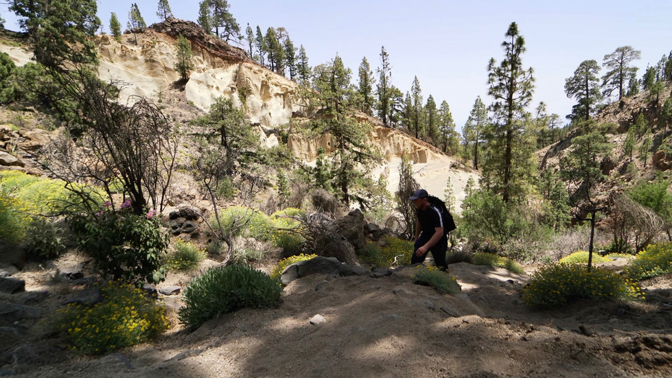
Day 3: The third day is probably the least scenic. However, you will see some highly unusual buildings on the way, which are really worth visiting. The fauna and flora will also delight you as a nature lover. Look out for dragon trees! So your hike is basically over hills, fields and through villages. At some point you will pass very close to the and airport, which I found very exciting at the time. After the village "La Esperanza" you slowly reach the jungle of Tenerife. The exciting part you will experience the next day. Before that, you will reach your destination for the day, the "Zona de Acampada de Las Calderetas", where you will spend your first night in a tent.
Don't forget to take an emergency bivouac with you. It consists of an emergency blanket that is cold-resistant, a whistle and a mini compass. It should be in your rucksack on every hike anyway.
As the old Scottish saying goes: "There's no such thing as bad weather, only bad clothes!"


Day 4: The campsite was very idyllic in a forest. I woke up gently to the soft sound of the nearby river and the cheerful chirping of birds. There is no place where you can enjoy nature and the simplicity of life as much as on a campsite on such a morning. I hope you experience a similar beautiful moment during your tour. But now we come to the exciting part of the fourth day, you can expect a grandiose mountain tour through the jungle of Tenerife. You will pass some places that offer you beautiful views of the island and the wide sea. Your destination for the day is again a campground with the bureaucratic sounding name "Zona de Acampada La Caldera". The campsite is idyllically located in a pine forest.

Day 5: The fifth day is perhaps the shortest hiking day. You have to continue up the mountain through the "Parque Natural de Corona Forestal". In between, your eyes will be drawn to the gigantic "Pico del Teide" every now and then. He is already an immense lump. Since you have then already left the jungle and there is little shade and you are also permanently exposed to the movements of the air, I recommend you at this point my beloved "Piz Buin Mountain" sunscreen, as well as my ultra light sun cap and wind blocker.
• Sun cap
"The sun also shines behind the clouds." Quote from Karl Friedrich Wilhelm Wander
At the end you reach the barren volcanic landscape of the "Parque Nacional del Teide". I could hardly believe my eyes there. The landscape is simply overwhelming. Unbelievable! Since the next day many meters of altitude are waiting for you, you should rest extensively. Then look forward to the next day, he will be a very special!
Day 6: If you have spent the night at the Refugio "Altavista" like I did, then I would strongly recommend the sunrise. Goosebumps! Some adventurers have also hiked up at night, so that is also recommended! The trail is not particularly difficult, but you should have a headlamp with you. It makes it easier to walk. Also remember the sunset, it is a wonderful and spiritual experience! Enjoy the pictures in the slider below!


Day 7: After a wonderful night in the Refugio "Altavista" it goes for you over an adventurous mountain path down to the "Parque Nacional del Teide". On the way you will pass the "Pico Viejo" and "Pico Sur", which you should have a closer look at. In the park you should still go the round hiking trail, there are really bizarre but worth seeing rock formations. At the end of the day the moon landscape is waiting for you. It is small but nice. Your day ends at a campsite in a pine forest.
Day 8: On the last day I had to process all the impressions I have gained so far. I knew that my trip was coming to an end soon and was looking forward to a last upcoming hike. You then have to go down into the valley and always have wonderful views of the west coast of Tenerife. If you made it, you earned my respect! Not an easy trip, but unforgettably beautiful. Congratulations!

Trekking tenerife best time
Tenerife often has a mix of sun, wind and clouds. The best time to travel to Tenerife is from April to October. The weather is consistently warm and invites both a beach vacation and an active vacation. For a winter vacation with snow guaranteed on Pico del Teide, the best time to travel is between December and February. On the low plains it remains mild with temperatures between 20-21 degrees Celsius. The spring and autumn months are the best time to travel to Tenerife, especially for hiking and trekking tours. It is not too hot and not too cold to explore the largest Canary Island. In principle, you can do the tour all year round, but in winter, the "Pico del Teide" could be covered with snow. So check before you start your tour.
If we want to travel far, we must first cross the near; if we want to climb high, we must start at the bottom. Confucius 551 B.C. - 479 B.C.

Trekking tenerife further information
ATM and credit cards are available in many places. You should still take cash with you on your trip.
Water: Unfortunately, you can't always find it. Look that your water tank is always well filled. I usually had about 3.5 liters with. Especially in the mountains, the water is significantly less. You should take a Water filter with you. The water may be clear, but it can still contain impurities, such as animal excrement or dead animals. However, you can also boil the water.
Animals or vermin: No poisonous reptiles or dangerous animals, such as snakes, scorpions or the like, are found anywhere in the Canary Islands. Even the lizards and geckos that can be found in many places are completely harmless.
Altitude sickness: Altitude sickness is caused by the reduced oxygen supply at high altitudes. Symptoms include headache, fatigue, loss of appetite, excitability, and in more severe cases, shortness of breath and confusion. At barely 4000m altitude, altitude sickness can already get you. Therefore, I recommend that you take it slow on the ascent. Take your time!
Surefootedness: To be safe on the trail, sure-footedness and the right footwear are the most important factors - after all, falls due to tripping and slipping are the most common cause of accidents when hiking. So remember: the right footwear and the right walking technique are therefore incredibly important. You are sure to find the right footwear in the article below!
Dangers: Teide's last eruption occurred in 1909, but the volcano is still active and is classified as "potentially dangerous." However, geologists are constantly monitoring Teide for signs of an impending eruption. I strongly suspect, should there be any danger from volcanic activity, the park administration would respond immediately and close the park. However, check thoroughly online before your tour.
Permit: In order to enter the summit area of the Teide volcano, you need a permit from the park administration. You can apply for this permit online through the park's official website. There are a limited number of permits available each day. It is therefore advisable that you book early. https://www.reservasparquesnacionales.es/real/parquesnac/usu/html/detalle-actividad-oapn.aspx?ii=8DEU&cen=2&act=1
There are two types of permits: One for access to the summit area and one for access to the cable car. The permit for the summit area allows you to visit the summit of Teide. The permit for the cable car allows you to visit the viewpoint at the altitude of 3,555 meters. With a reservation at Refugio Altavista, a sunset permit is included.
In the very early morning hours, there were no park rangers far and wide where I was.


Tenerife hike gear list
Here I recommend the most important hiking equipment that I own, have tested myself and have also bought myself. I pay a lot of attention to the weight and quality of my equipment. The equipment should simply feel good on longer tours and also be light. I can recommend the equipment for women because my wife uses it and it is basically the same as the equipment for men.
Note: Please keep in mind that the packing list is general and you will have to adapt it depending on the season and your needs!
Advertising note: These product links are affiliate links. If you buy something through one of these links, I will receive a small commission without you having to pay more. This is for the maintenance of my blog and you support me with my project, for which I am very grateful. Thank you very much!
Clothes
Hiking boots
Hiking shorts
Long hiking pants
Functional shirt
Hybridjacket
Fleece-jacket
Rain jacket
Functional underwear
Hiking socks
Other hiking equipment:
• Sun cap
Hiking backback (approx. 60 litres or as required)
by EXPED - unfortunately not available on Amazon.
• Backback - Ospray (was my old one and is also good)
Technology and orientation:
• Compass
• Headlamp
• GPS device or GPS watch if necessary
• Binoculars if necessary
Catering:
• Sweets to keep up morale :)
Health & first Aid:
• First Aid (small and light)
• Tape
• Bivouac
• Toilet paper
Other:
• Passport/Insurance certificate
• cash
• Gas cartridge
Film equipment:
• Camera
• Drone
• Tripod
• Clip

GR131 GPX
The GPX files are available for download from the following providers.
Outdooractive: https://out.ac/3vJiir
Komoot:
Bergfex: https://www.bergfex.at/sommer/kanaren/touren/fernwanderweg/2658310,gr-131-fernwandern-auf-teneriffa-nord-sued/
Tenerife hike map

Long-distance hiking trails in Europe: 90 routes, all countries
Wild & adventurous: these are the most beautiful long-distance hiking trails in Europe.
Safety advice
All the safety rules of mountain sports also apply to hiking and trekking! You can find the safety rules in the link below:
Trekking tenerife conclusion
The island crossing with a length of almost 105 km is a fantastic long-distance hiking trail that offers an incredible amount. It shows a cross section of the beautiful landscape of Madeira. I really enjoyed the tour! It is my absolute favorite tour. Have a great time and good luck ;)
As always, I would be very happy about a feedback via one of my channels.
Feel free to leave me a comment here as well.

Hello, I am Christian, the chief globetrotter of this Site and an enthusiastic adventurer, hiker and filmmaker. I love to explore new paths and inspire people with them, and I love to share my hiking knowledge with you! You can also find my videos on YouTube! On my blog you can find tips for beginners and professionals on the greatest and most beautiful hiking tours there are. I want to encourage people to explore the world as a hiker, whether in the countryside, through the forest or in the mountains. True to the motto: If you haven't hiked, you haven't seen the world,
On my blog, I also write about hiking gear, the right summit training and nature conservation, as well as tips and information about hiking.


Hi Christian, thank you for this description! I'll be in Tenerife this winter and I really want to do this hike. I'm finding it difficult to find some of the places have have mentioned along the way. Do you have maybe like a GPX file or a link to the route or something like that? Did you follow a specific path or kind of made your own? Thank you for your help and for the inspiration! - Natalia
Thank you